
Pricing Change
New pricing for orders of material from this site will come into place shortly. Charges for supply of digital images, digitisation on demand, prints and licensing will be altered.
Upcoming Maintenance
Please be advised that this website will undergo scheduled maintenance on the following dates:
Thursday, 9 January: 11:00 AM - 3:00 PM
Thursday, 23 January: 11:00 AM - 3:00 PM
Thursday, 30 January: 11:00 AM - 3:00 PM
During these times, some functionality such as image purchasing may be temporarily unavailable. We apologise for any inconvenience this may cause.
Beattock Hill


Building (Medieval) - (Post Medieval), Scooped Settlement (Iron Age)
Site Name Beattock Hill
Classification Building (Medieval) - (Post Medieval), Scooped Settlement (Iron Age)
Canmore ID 48374
Site Number NT00SE 14
NGR NT 06939 02422
Datum OSGB36 - NGR
Permalink http://canmore.org.uk/site/48374


- Council Dumfries And Galloway
- Parish Kirkpatrick-juxta
- Former Region Dumfries And Galloway
- Former District Annandale And Eskdale
- Former County Dumfries-shire
NT00SE 14 0693 0242
Earthwork (NR)
OS 6" map, 1957.
A circular fort, about 110' in diameter, surrounded by a stony rampart or wall some 20' wide at base, entered from the ENE. Close by the wall and about 25' from the entrance are the 2'6" thick, dry-stone foundations of a rectangular structure, 19' by 8'. On the S arc of the defenses there has been either a double wall or a 4' wall with an 8' banquette on the interior.
RCAHMS 1920, visited 1912
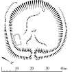
A scooped settlement, measuring internally 34.0m NW-SE by 32.5m within an earth-and-stone bank up to 1.8m high by the entrance in the NE. The site has been levelled into the slope to a depth of 1.7m on the W, and this scarp is crowned by the robbed remains of a stone wall up to 3.0m wide.
The interior contains several grassy platforms, probably representing the sites of houses, and the entrance has a characteristic hollowed effect. Overlying the settlement wall on the E are the slight remains of a sub-rectangular structure which measures about 5.0m by 2.8m within a stone wall up to 1.1m wide.
Resurveyed at 1/2500
Visited by OS (D W R) 6 September 1973
No change to previous field report.
See plan
Visited by OS (T R G) 22 September 1978.
Settlement [NAT]
OS 1:10,000 map, 1982.
Note (23 April 1990)
NT 0693 0242 NT00SE 14
The severely-robbed remains of this scooped settlement are situated on a terrace on the E flank of Beattock Hill. Roughly circular on plan, it measures about 34m in diameter within a wall now reduced to a grass-grown stony bank up to 6m thick and 0.6m high. Inner and outer facing-stones are visible at a number of points on the circuit, but the lines of both faces around much of the W side are now marked only by robber-trenches. The entrance is situated on the NE and the interior has been scooped to a depth of at least 1.5m into the natural slope.
Immediately within the entrance there is a shallow hollow which leads towards the rear where there are the vestiges of a platform, the front of which is marked by a low scarp. Within the SE part of the interior, there are the turf-covered footings of a small subrectangular building which measures about 7.2m from NE to SW by 4m transversely overall; it has an entrance on its NW side.
Visited by RCAHMS (JRS), 23 April 1990.
Listed as settlement and (overlying) building.
RCAHMS 1997.
Measured Survey (11 October 1990)
RCAHMS surveyed the scooped settlement at Beattock Hill on 11 October 1990 with plane-table and self-reducing alidade at a scale of 1:500. The plan was redrawn in ink and published at a scale of 1:1000 (RCAHMS 1997, Fig. 61).

