
Following the launch of trove.scot in February 2025 we are now planning the retiral of some of our webservices. Canmore will be switched off on 24th June 2025. Information about the closure can be found on the HES website: Retiral of HES web services | Historic Environment Scotland
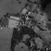
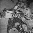
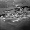
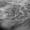
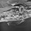
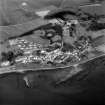
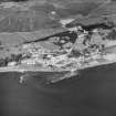
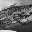
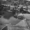
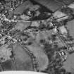
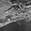
Culross, General


Burgh (Medieval), Village (Period Unassigned)
Site Name Culross, General
Classification Burgh (Medieval), Village (Period Unassigned)
Canmore ID 48046
Site Number NS98NE 32
NGR NS 98588 85982
Datum OSGB36 - NGR
Permalink http://canmore.org.uk/site/48046

![Scanned image of IGL W434/12/3 [negative number to be supplied].](http://i.rcahms.gov.uk/canmore/l/SC00840993.jpg)


![Scanned image of IGL W434/1/12 [negative number to be supplied].](http://i.rcahms.gov.uk/canmore/l/SC00840907.jpg)


![Scanned image of IGL W434/1/1 [negative number to be supplied].](http://i.rcahms.gov.uk/canmore/l/SC00840906.jpg)
![Scanned image of IGL W434/4/5 [negative number to be supplied].](http://i.rcahms.gov.uk/canmore/l/SC00840908.jpg)
![Scanned image of IGL W434/14/5 [negative number to be supplied].](http://i.rcahms.gov.uk/canmore/l/SC00840994.jpg)


![Scanned image of IGL W434/12/3 [negative number to be supplied].](http://i.rcahms.gov.uk/canmore/s/SC00840993.jpg)


![Scanned image of IGL W434/1/12 [negative number to be supplied].](http://i.rcahms.gov.uk/canmore/s/SC00840907.jpg)


![Scanned image of IGL W434/1/1 [negative number to be supplied].](http://i.rcahms.gov.uk/canmore/s/SC00840906.jpg)
![Scanned image of IGL W434/4/5 [negative number to be supplied].](http://i.rcahms.gov.uk/canmore/s/SC00840908.jpg)
![Scanned image of IGL W434/14/5 [negative number to be supplied].](http://i.rcahms.gov.uk/canmore/s/SC00840994.jpg)


- Council Fife
- Parish Culross
- Former Region Fife
- Former District Dunfermline
- Former County Fife
NS98NE 32 98 85.
Culross was erected a burgh of barony belonging to the abbot of Culross in 1490; it became a royal burgh in 1592.
G S Pryde 1965.
REFERENCES:
SCOTTISH NATIONAL PORTRAIT GALLERY:
Country Life: 23rd January 1948, 3rd October 1947, June 1951 - photographs and articles.
Glasgow Architectural Association Sketch Book. 1887 vol.11 - Photographs of tympanum and windows (possibly Culross Abbey?)
Non-Guardianship Sites Plan Collection, DC23302- DC23376, 1933,1936- 1938, 1945 -1947,1950- 1951 &
1953- 1954.
Non-Guardianship Sites Plan Collection, DC28947- DC28960, 1951, 1953 -1954 & 1957 - 1959.
Photographic Survey (1938)
Photographs of buildings in Culross, Fife by the Ministry of Works c1938.
Photographic Survey (July 1954)
Photographs of buildings in Culross, Fife, by the National Buildings Record Scottish Council in July 1954.
Publication Account (1987)
Culross presents one of the most visually exciting but chronologically confused series of buildings in Scotland. The value of these monuments was recognised in the 1930s when the Fife Inventory was produced and the National Trust for Scotland set up its 'Little Houses Scheme' in an effort to save the most interesting buildings. The project was a great success and the town is now largely NTS property. It attracts large numbers of tourists and has been used as a backdrop to many historical films and television programmes.
Careful study of the town plan appears to reveal three wide medieval streets now built over; later road improvements have cut through the burgess' feus to disguise further the original planning intention. The original medieval street appears to run from the cross to the Sandhaven, the northern building line being the north side of Back Causeway, the southern, the south side of Mid Causeway. This assumption is based on the pattern of the burgess' feus but appears to be confirmed by a town plan in the Report on the Parliamentary Boundaries of Scotland 1832. The Sandhaven appears to have been the second medieval street perhaps originally running behind the tolbooth (Town House) and terminating at Culross Palace. The third street is at the bottom of the Little Causeway running parallel to the shoreline of the Firth of Forth and continuing into the Dunfermline road.
It should be noted, however, that few if any of the surviving buildings in the area of the original medieval street are older than the 17th century, although one or two of them incorporate earlier datestones, while buildings on other medieval streets are all of late 17th century date or, in many cases, even later. The base of the market cross, situated at the head of Back and Mid Causeway, dates from the late 16th century, but the shaft and head are modem.
The street pattern suggested above does much to relate the Culross burgh plan to those of other prosperous medieval burghs, and the later abandonment of the medieval plan reflects the changing fortunes of the town in the late 19th and early 20th centuries. The depressed nature of this community in the recent past is also reflected in the roof coverings as the pantiled roof coverings appear as late replacements for formerly thatched roofs. The fact that the pantile was, in Fife, considered an inferior roofing material can be confirmed both visually and through documentary sources. The visual evidence is the lack of pantiles in those burghs remaining prosperous in the 19th century, where the common roofing material is slate, whereas those burghs which were depressed have pan tiled roofs. See also no. 39 for Culross Palace.
Information from ‘Exploring Scotland’s Heritage: Fife and Tayside’, (1987).

