|
Prints and Drawings |
SUD 109/1 |
|
Plans figs PSAS 1-4 Reid et al |
1966 |
Item Level |
|
|
Prints and Drawings |
SUD 109/2 |
|
Plans figs PSAS 1-4 Reid et al |
1966 |
Item Level |
|
|
Prints and Drawings |
SUD 109/3 |
|
Plans figs PSAS 1-4 Reid et al |
1966 |
Item Level |
|
|
Prints and Drawings |
SUD 109/4 |
|
Plans figs PSAS 1-4 Reid et al |
1966 |
Item Level |
|
|
Prints and Drawings |
SUD 109/5 |
|
Plans figs PSAS 1-4 Reid et al |
1966 |
Item Level |
|
|
Prints and Drawings |
SUD 109/6 |
|
Plans figs PSAS 1-4 Reid et al |
1966 |
Item Level |
|
|
Prints and Drawings |
SUD 109/7 |
|
Plans figs PSAS 1-4 Reid et al |
1966 |
Item Level |
|
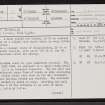 |
On-line Digital Images |
SC 2346681 |
Records of the Ordnance Survey, Southampton, Hampshire, England |
Loch Borralie, NC36NE 32, Ordnance Survey index card, page number 1, Recto |
c. 1958 |
Item Level |
|
 |
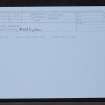
On-line Digital Images |
SC 2346682 |
Records of the Ordnance Survey, Southampton, Hampshire, England |
Loch Borralie, NC36NE 32, Ordnance Survey index card, page number 2, Verso |
c. 1958 |
Item Level |
|
 |
On-line Digital Images |
SC 2346683 |
Records of the Ordnance Survey, Southampton, Hampshire, England |
Loch Borralie, NC36NE 32, Ordnance Survey index card, Recto |
c. 1958 |
Item Level |
|
|
All Other |
551 166/1/1 |
Records of the Ordnance Survey, Southampton, Hampshire, England |
Archaeological site card index ('495' cards) |
1947 |
Sub-Group Level |
|


