
Mumrills


Enclosure(S) (Roman)
Site Name Mumrills
Classification Enclosure(S) (Roman)
Canmore ID 47890
Site Number NS97NW 29
NGR NS 92066 79394
Datum OSGB36 - NGR
Permalink http://canmore.org.uk/site/47890


- Council Falkirk
- Parish Falkirk
- Former Region Central
- Former District Falkirk
- Former County Stirlingshire
NS97NW 29 92066 79394
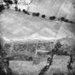
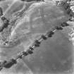
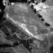
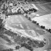
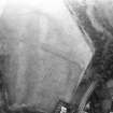
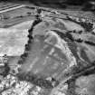
A rectilinear enclosure, visible as crop-markings on CUCAP air photographs (DH 32-3), situated at NS 9208 7940, some 150m E of Mumrills Roman fort (NS97NW 10), was examined by Miss A S Robertson in 1960. It proved to be a temporary Roman work, bounded by a single ditch with (presumably) a palisaded upcast bank inside it, and measured 130ft internally from north-east to south-west. The transverse dimension was at least 95ft but could not be accurately determined since the whole of the south-east side of the enclosure has been destroyed by erosion of the steep scarp of the plateau.
In the centre of the north-west side an entrance was defined by two post-holes, 5ft apart, situated on the line of the presumed bank and facing a gap in the ditch 9ft in width. As the post-holes were 1ft in diameter but only 1ft in depth it was evident that ploughing had removed at least 1ft of the sand and gravel subsoil since Roman times. But although no trace of the bank survived in situ, it seems reasonable to suppose that it was composed simply of upcast from the ditch since there was no trace of turf or clay in the ditch filling. The Roman origin of the enclosure was proved by its shape, and by the discovery of amphora fragments lying on the subsoil at the bottom of the ditch; while an Antonine date was established by a piece of a flat-rimmed bowl in black-burnished ware, found in the primary slit. A number of other Roman sherds, all apparently of the second century, were also found higher up in the filling of the ditch. The purpose of the enclosure is uncertain, though its slight nature suggests that it was intended to hold stores rather than to accommodate troops. Exploratory trenches in the interior revealed several widely scattered post-holes, but one of these was probably post-Roman since a piece of a column shaft had been used as a packing-stone. A post-Roman date must certainly be assigned to a small oval ditched enclosure which can be seen on the air-photographs adjoining the north-east side of the Roman enclosure, and which proved to incorporate part of the latter's ditch in its circuit. Owing to the general denudation of the area, however, it did not seem worth while to pursue the exploration of this later feature. Traces of what may have been a Roman building were found very close to, if not actually within, this enclosure in 1937 (S Smith 1939). (For plan, see Steer 1963, or RCAHMS 1963).
S Smith 1939; K A Steer 1963; RCAHMS 1963.
Scheduled with NS97NW 10, NS97NW 45, NS97NW 46.00, NS97NW 46.10 as 'Antonine Wall, Mumrills fort, Sandy Loan to A905, Falkirk'.
Information from Historic Scotland, scheduling document dated 13 June 2001.
Publication Account (2008)
A 1:25000 scale map of the Antonine Wall was published by RCAHMS in 2008. The map shows the course of the Antonine Wall on a modern map base, including areas where the Wall is in public ownership or care and can be visited. The data had been collated as part of the project to prepare maps for the World Heritage Site nomination bid.

