
Pricing Change
New pricing for orders of material from this site will come into place shortly. Charges for supply of digital images, digitisation on demand, prints and licensing will be altered.
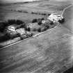
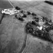
Covington Tower


Motte (Medieval)(Possible), Tower House (Medieval)
Site Name Covington Tower
Classification Motte (Medieval)(Possible), Tower House (Medieval)
Alternative Name(s) Covington Castle
Canmore ID 47485
Site Number NS93NE 3
NGR NS 97482 39888
Datum OSGB36 - NGR
Permalink http://canmore.org.uk/site/47485


- Council South Lanarkshire
- Parish Covington And Thankerton
- Former Region Strathclyde
- Former District Clydesdale
- Former County Lanarkshire
NMRS REFERENCE
Originally the manor house of the Lindsays of Covington. 15th Century type of square baronial fortress.
EXTERNAL REFERENCE
National Portrait Gallery - Article and photograph
'Glasgow and Lanarkshire Illustrated'
1910, Cat. 1935, c/July 1946. p. 133
Field Visit (24 January 1968)
Covington Tower is of coursed rubble masonry, the walling varying from 7.0m to 14.0m in height and 3.3m thick. It, and the earthworks are as planned and described by the previous authorities.
Surveyed at 1:2500.
Visited by OS(WDJ) 24 January 1968.
Desk Based Assessment (13 May 1968)
NS93NE 3.00 97482 39888
NS93NE 3.01 NS 9752 3993 Dovecot
(NS 9748 3988) Tower (NR) (remains of)
OS 25" map, (1972).
Castle (NR) (Remains of)
OS 6" map, (1957).
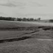
The motte at Covington marked a 12th century grant of land (W M Mackenzie 1927), presumably the motte on or near which the probably 15th century castle (Cruden 1960) / tower (Christison 1890) was built. The walls of the tower form the inner side of a trench (A, See D Christison plan etc) 8ft to 10ft wide and 2ft to 3ft deep on all sides except the N, where there is an entrance. They stand within and to the E side of an area 150ft square surrounded by a flat-bottomed trench (B) 5ft to 7ft deep, nearly obliterated on the N by farm buildings. The whole occupies the NW corner of an area, about 450ft by 350ft,
outlined by a trench (C) intact on the W side but mutilated by modern roads to S and E. A terrace (G) may be the remains of the old motte: the rectangular area (F) was 'no doubt' the garden. The trenches are, and always have been, dry (Christison 1890).
Information from OS (DT) 13 May 1968
See also MacGibbon and Ross 1897, 239-41.
Field Visit (22 February 1979)
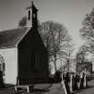
Covington Tower (Information from The Tenant, Covington Mains), stands within a moat which has associated earthworks to the S and E. There is no evidence of a motte although the tower stands on fairly high ground. Much of the dressed stone from the decaying tower has been robbed but the majority of the arrow slits and some quoins survive in situ. The trench (A on D Christison's plan) at the base of the tower has no apparent significance and may only be the result of a minor excavation. The moat is 40.0m square internally with arms up to 10.0m wide and 2.2m deep; the N side is partially infilled and the E side is being filled with farm debris. The moat is dry but the farmer (at Covington Mains) states that it was seasonally wet until about 15 years ago.
The associated earthworks (C and F) are generally as described.
Visited by OS(MJF) 22 February 1979.
Excavation (1982)
NS 975 399. Excavation of the the internal ground floor area was carried out in advance of restoration work to the ruin. An average 0.75m depth of modern accumulation and fallen stone was first removed. This revealed a clay floor surface covered with lime mortar, varying up to 0.15m in depth. This mortar may be the residue of a demolition process. Features in the floor were several post holes and log trenches, which are interpreted as being associated with the entresol floor and a wooden partition. Pockets of occupation material produced quantities of early window and bottle glass, pottery, tin-plated pins, bone and a stone cannon ball weighing 11lb. Also found outside the tower, a decorated lead caste whorl. Finds lodges in Biggar Museum
Sponsor: Lanark & District Archaeological Society
T Ward 1982.

