
Pricing Change
New pricing for orders of material from this site will come into place shortly. Charges for supply of digital images, digitisation on demand, prints and licensing will be altered.
Berries Burn


Fort (Prehistoric), Ring (Stone)(Period Unknown), Unidentified Object(S) (Iron)(Period Unknown), Unidentified Pottery (Iron Age), Whetstone (Period Unknown)
Site Name Berries Burn
Classification Fort (Prehistoric), Ring (Stone)(Period Unknown), Unidentified Object(S) (Iron)(Period Unknown), Unidentified Pottery (Iron Age), Whetstone (Period Unknown)
Alternative Name(s) Castle Crawford Farm
Canmore ID 47384
Site Number NS92SE 1
NGR NS 9517 2187
Datum OSGB36 - NGR
Permalink http://canmore.org.uk/site/47384


- Council South Lanarkshire
- Parish Crawford
- Former Region Strathclyde
- Former District Clydesdale
- Former County Lanarkshire
Excavation (May 1939 - June 1939)
Berries Hill was excavated by Childe according to his manuscript notebook in the vicinity of the rampart in May/June 1939 with J.I. Sutherland as foreman, and other labourers (Notebook 65; Childe 1939a: 257) discovering Iron Age material but no secure post-holes.
I Ralston 2009
Field Visit (20 July 1959)
When visited in 1959, this fort was in a similar condition to that described above.
Visited by OS (WDJ) 20 July 1959
Measured Survey (21 August 1968)
The fort at Berries Burn was surveyed by RCAHMS on 21 August 1968 at a scale of 1mm : 1ft (c. 1:300). The survey drawing (LAD 127/1) was later redrawn in ink (LAD 127/2) and the survey was reproduced at a much reduced scale in 1978 as Fig. 46.
Field Visit (August 1975)
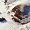
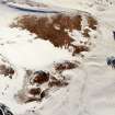
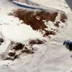
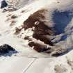
Fort, Berries Burn.
On the summit of an isolated knoll on the right bank of the Berries Burn, 520 m NW of Castle Crawford farmhouse and at a height of 290 m
OD, there are the slight remains of a fort, measuring 108m by 38m within a much-ruined wall. At the NE and SW ends of the fort, where it is best preserved, the wall appears as a grass-covered stony bank 2.4m in average thickness and 0.3m high, in which three short stretches of outer facing stones have survived in situ. On the SE, however, it has apparently collapsed down the steep flank of the knoll, while, for the rest of the circuit, it has been reduced to a mere scarp. The core material for the wall was apparently obtained from an intermittent external quarry-ditch, slight traces of which can still be seen on the NE and SW, as shown on the plan. Additional protection was provided on the W and NE where the fort is immediately overlooked by rising ground, by an outer bank, now much worn and appearing as a low grassy scarp. The entrance, in the SSW, is 4.0m wide.
Although the interior of the fort falls sharply from NW-SE there are no surface indications of terraced platforms for timber houses, nor were any internal structures noticed when the fort was partially excavated in 1939 (Proc Prehist Soc 1939). The relics recovered during the excavation, and placed in the National Museum of Antiquities of Scotland (NMAS), include several sherds of Early Iron Age pottery, a stone ring, a hone and small fragments of iron.
RCAHMS 1978, visited August 1975
Field Visit (14 August 1978)
NS92SE 1 9517 2187.
(NS 95172187) Fort (NR) OS 6" map (1962)
This fort is as described and planned by the RCAHMS.
Surveyed at 1:2500.
Visited by OS (TRG) 14 August 1978
Note (25 August 2014 - 23 May 2016)
This fort is situated on an elongated knoll that rises from the foot of the SE flank of the spur named Ritchie Ferry. Oval on plan, it measures 108m from NE to SW by 38m transversely (0.33ha) within a ruinous wall largely reduced to a stony scarp but at either end forming a low bank about 2.4m in thickness. Here and along the NW flank traces of a ditch can be seen, and this has evidently been accompanied by a counterscarp bank on the NE and NW. There are gaps in the rampart on the SW and E, though the RCAHMS investigators who drew up a plan in 1968 only seem to have considered that on the SW to be an original entrance. The interior is featureless, but Professor Gordon Childe excavating in 1939 recovered sherds of coarse [pottery], a stone ring, a hone and several small fragments of iron (Proc Prehist Soc 1939, 257).
Information from An Atlas of Hillforts of Great Britain and Ireland – 23 May 2016. Atlas of Hillforts SC1667

