
Tullibody, Haer Stane


Socketed Stone (Prehistoric)(Possible), Stone Circle (Neolithic) - (Bronze Age)(Possible), War Memorial (20th Century)
Site Name Tullibody, Haer Stane
Classification Socketed Stone (Prehistoric)(Possible), Stone Circle (Neolithic) - (Bronze Age)(Possible), War Memorial (20th Century)
Alternative Name(s) Baingle Brae Villa; Haer Stone; Cross
Canmore ID 47212
Site Number NS89SE 5
NGR NS 85656 94750
Datum OSGB36 - NGR
Permalink http://canmore.org.uk/site/47212


- Council Clackmannan
- Parish Alloa
- Former Region Central
- Former District Clackmannan
- Former County Clackmannanshire
NS89SE 5 8565 9475.
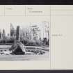
(Area: NS 857 949) The Haer Stane of Tullibody is a shapeless mass of basalt about 8ft high and 30ft round the base which stands on the declivity in front of Baingle Brae Villa. Within the memory of persons living in 1874, it was surrounded by a great number of rough upright stones, about 2 to 3ft high, methodically arranged. North-east of the stone, but within the enclosure, was an old well.
Five or six hundred yards NW from the Haer Stane, the site of the "stannin' stane", demolished c.1824, was still pointed out in 1874.
J Crawford 1874; A L Drummond 1937
NS 8565 9475. Inserted into the top of this large erratic boulder, is a modern war memorial stone. Encircling the boulder are approximately 60 small loose stones giving a diameter of about 10.0m. These stones are not in situ due to the construction of a pond, precluding positive identification of a stone circle.
No further information was found regarding the 'stannin' stane'.
Visited by OS (DWR) 8 February 1973.
Field Visit (August 1977)
Haer Stane, Tullibody NS 856947 NS89SE 5
The large boulder that forms the base of the War memorial in the public park is all that survives of what may have been a stone circle; the stone is about 3 m in diameter and 2 m in height, and is said to have been surrounded, until the middle of the 19th century, by 'a great number of rough upright stones, methodically arranged, and in general about two or three feet in height.
RCAHMS 1978, visited August 1977.
(Crawford 1874, 23-4; Drummond 1937, 118)

