
Alloa Gasworks


Gas Works (19th Century)
Site Name Alloa Gasworks
Classification Gas Works (19th Century)
Canmore ID 47209
Site Number NS89SE 48
NGR NS 87875 92445
NGR Description Centred on NS 87875 92445
Datum OSGB36 - NGR
Permalink http://canmore.org.uk/site/47209


- Council Clackmannan
- Parish Alloa
- Former Region Central
- Former District Clackmannan
- Former County Clackmannanshire
NS89SE 48 879 923.
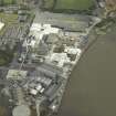
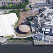
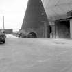
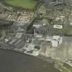
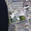
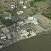
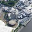
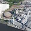
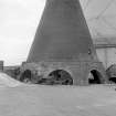
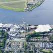
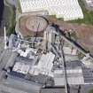
Alloa Gasworks are situated c 30m from the bank of the Forth and lie immediately to the west of Alloa Glass Works. The site is dominated by a huge metal cylindrical gas holder.
Site recorded by GUARD during the Coastal Assessment Survey for Historic Scotland, 'The Firth of Forth from Dunbar to the Coast of Fife' 24 February 1996.
NS89SE 48 centred on 87875 92445
See also NS89SE 121 Alloa, Bank Street, Gas Showroom
Field Visit (24 February 1996)
Alloa Gasworks are situated c 30m from the bank of the Forth and lie immediately to the west of Alloa Glass Works. The site is dominated by a huge metal cylindrical gas holder.
Site recorded by GUARD during the Coastal Assessment Survey for Historic Scotland, 'The Firth of Forth from Dunbar to the Coast of Fife' 24 February 1996.
Archaeological Evaluation (March 2022)
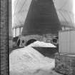
NS 8795 9240 A trial trench evaluation was undertaken, in March 2022, in advance of constructing an air separation unit. Nine trial trenches were excavated that targeted potential features highlighted on historic mapping. The majority of the trenches contained brick floor surfaces and a few small sections of foundation wall related to 19th- and 20th-century industrial activity on the site. The most significant feature was a likely brick pottery kiln base not noted on any of the historic maps. The possible remains of a rectangular brick kiln noted on the 1862 map were also uncovered.
Archive: NRHE (intended) Funder: Air Products BR Ltd
Steven Black – Clyde Archaeology
(Source: DES Volume 23)

