
Pricing Change
New pricing for orders of material from this site will come into place shortly. Charges for supply of digital images, digitisation on demand, prints and licensing will be altered.
University Of Stirling


Standing Stone (Prehistoric)
Site Name University Of Stirling
Classification Standing Stone (Prehistoric)
Canmore ID 47166
Site Number NS89NW 9
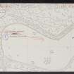
NGR NS 80604 96871
Datum OSGB36 - NGR
Permalink http://canmore.org.uk/site/47166


- Council Stirling
- Parish Logie (Stirling)
- Former Region Central
- Former District Stirling
- Former County Stirlingshire
NS89NW 9 80604 96871
(NS 8061 9687) Standing Stone (NR)
OS 6" map (1958)
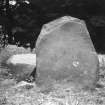
This standing stone has been removed since the date of visit by the RCAHMS. It had fallen many years ago, and when visited, the basal portion, 3' 10" high, had been re-erected, with two large fragments lying at its base. The original stone is said (A F Hutchison 1893) to have been 9'4" high. The re-erected part measures 2' 10" x 1' 10" at base. RCAHMS 1963, visited 1952
NS 8060 9686. This stone has been repaired and re-erected.
Visited by OS (JP) 18 December 1973
Field Visit (23 August 1952)
Standing Stone, Airthrey Castle (W.).
This stone stands 700 yds. WNW. of Airthrey Castle, just outside the wood that borders this part of the policies, at an elevation of about 140 ft. O.D. Many years ago the stone, which is of dark grey dolerite, fell down and was broken, and the basal portion, now re-erected (Pl. 3 A [ST 109]), is only 3 ft. 10 in. high; two large fragments, however, still lie beside the base, and the original stone is said (1) to have stood to a height of 9 ft. 4 in. Of a more or less oblong section throughout, there-erected stone measures 2 ft. 10 in. by 1 ft. 10 in. at ground level, swells to its greatest dimensions (3 ft. 2 in. by 1 ft. 9 in.) at a height of 1 ft. 4 in., and diminishes at the top to 2 ft. 2 in. by 1 ft. 3 in. Its major axis lies approximately ENE. and WSW.
Since the date of visit this stone has been removed.
RCAHMS 1963, visited 23 August 1952
(1) TSHNAHS, xv, 119 and pl. III. An illustration of this stone is given by Fergusson, R Menzies, Logie, A Parish History, ii, facing p. 244
Field Visit (September 1978)
Airthrey Castle 2 NS 806 968 NS89NW 9
This stone has been re-erected; originally it stood 2.8m high.
RCAHMS 1979, visited September 1978
(RCAHMS 1963, p. 66, no. 47)

