
Pricing Change
New pricing for orders of material from this site will come into place shortly. Charges for supply of digital images, digitisation on demand, prints and licensing will be altered.
Third Inchna Burn


Archaeological Landscape (Medieval) - (Post Medieval)
Site Name Third Inchna Burn
Classification Archaeological Landscape (Medieval) - (Post Medieval)
Alternative Name(s) Red Brae
Canmore ID 47161
Site Number NS89NW 54
NGR NS 8470 9910
NGR Description Centred on NS 8470 9910
Datum OSGB36 - NGR
Permalink http://canmore.org.uk/site/47161


- Council Stirling
- Parish Logie (Stirling)
- Former Region Central
- Former District Stirling
- Former County Stirlingshire
Field Visit (13 February 1974)
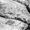
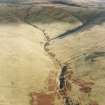
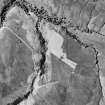
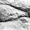
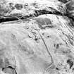
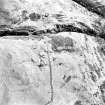
Post-medieval fields and enclosures.
Visited by OS (JP) 13 February 1974.
Field Visit (4 June 1997)
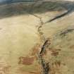
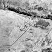
NS89NW 54.00 centred on 8470 9910
NS89NW 54.01 NS 8466 9888 Farmstead (MENS97 18-21)
NS89NW 54.02 NS 8470 9910 Field-system; Head-dyke; Cultivation Terraces; Rig
NS89NW 54.03 NS 8445 9938 Hut (MENS97 22)
NS89NW 54.04 NS 8496 9958 Hut; Sheepfold; Trackways (MENS97 124-5)
The sides of the spur between the Second and Third Inchna Burns are enclosed by a head-dyke and covered by field banks and rig (54.02). A farmstead (54.01) lies at the centre of the cultivated ground and there is an isolated hut or pen (54.03) at the edge of a field to the S of the Third Inchna Burn. A sheepfold, or bucht, overlies the head-dyke and there is a hut just outside the head-dyke (54.04). Trackways cut across the spine of the spur and lead up on to the unenclosed hill to the NE.
(MENS97 18-22; 124-5)
Visited by RCAHMS (DCC) 22 April and 4 June 1997

