
Wester Carmuirs


Temporary Camp (Roman)
Site Name Wester Carmuirs
Classification Temporary Camp (Roman)
Canmore ID 46925
Site Number NS88SE 27
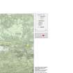
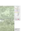
NGR NS 85177 80582
Datum OSGB36 - NGR
Permalink http://canmore.org.uk/site/46925


- Council Falkirk
- Parish Falkirk
- Former Region Central
- Former District Falkirk
- Former County Stirlingshire
NS88SE 27 85177 80582
(NS 85177 80582) Roman Camp (R) (site of)
OS 6" map (1967)
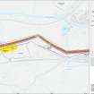
This Roman camp is situated on a slight eminence 700 yds SE of Carmuirs. Only three sides were known from air photographs (540/801:3044-5) in 1958 when the RCAHMS made their plan (camp G on plan of NS88SE 22) which was copied by the OS. However, in 1961, the whole perimeter of the camp, and the positions of the S and E gates, were noted. It measured 775' N-S by about 660'.
J K St Joseph 1961; RCAHMS 1963, visited 1958.
Photographed by the RCAHMS in 1976 and 1978.
(Undated) information in NMRS.
Reference (1957)
This site is noted in the ‘List of monuments discovered during the survey of marginal land (1951-5)’ (RCAHMS 1957, xiv-xviii).
Information from RCAHMS (GFG), 24 October 2012.
Note (1978)
Wester Carmuirs, NS 851 805 NS88SE 27
Listed as a temporary camp.
RCAHMS 1978
(St Joseph 1961, 122-3; RCAHMS 1963, pp. 107-12, No. 122 (Camelon, Temporary Camp ‘G’))
Publication Account (2008)
A 1:25000 scale map of the Antonine Wall was published by RCAHMS in 2008. The map shows the course of the Antonine Wall on a modern map base, including areas where the Wall is in public ownership or care and can be visited. The data had been collated as part of the project to prepare maps for the World Heritage Site nomination bid.
Publication Account (17 December 2011)
To the west of Lochlands Three Bridges, south of the main Lochlands complex and only 500m north of the Antonine Wall, lies the cropmark camp at Wester Carmuirs, first recorded in 1957 by St Joseph from the air (1958: 89). This camp is slightly irregular, but measures about 245m from NNE to WSW by 225m, enclosing almost 5.3ha (13 acres). Gaps, some of which may be for entrances, are visible on all four sides. There have been no excavations on the camp and no dating evidence is available. A further rounded corner visible to the west suggests that there may be another in this vicinity (see Wester Carmuirs II, possible camps). Owing to the similarity of the size of this camp with some of the presumed construction camps for the Wall (Garnhall I, Balmuildy, and possibly Dullatur I) it is usually associated with the Wall, although the camps do have slightly differing morphology. It is also suggested that it may equally have been a construction camp for the fort of Camelon (Hanson and Maxwell 1986: 118), although it had earlier been tentatively suggested that it may be Agricolan in date (Maxwell 1981: 42). A construction camp for the Wall seems the most likely on current evidence.
R H Jones.

