|
Prints and Drawings |
STD 9/1 |
Records of the Royal Commission on the Ancient and Historical Monuments of Scotland (RCAHMS), Edinbu |
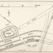
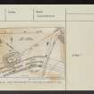
Publication drawing; Motte, Bonnybridge; plan as surveyed in 1933. |
1934 |
Item Level |
|
|
Prints and Drawings |
STD 9/2 |
Records of the Royal Commission on the Ancient and Historical Monuments of Scotland (RCAHMS), Edinbu |
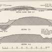
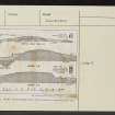
Publication drawing; Motte, Bonnybridge; sections as surveyed in 1933. |
1934 |
Item Level |
|
|
Photographs and Off-line Digital Images |
DC 47351/7 |
Records of the Ordnance Survey, Southampton, Hampshire, England |
Ordnance Survey 6-inch to the mile Provisional Edition, revision of 1913 with additions in 1946.
Additional annotations by Ordnance Survey for the Antonine Wall map covering the parishes of Dunipace and Denny with Bonnybridge. |
c. 1946 |
Item Level |
|
|
Manuscripts |
MS 2731 |
General Collection |
Report: 'An Archaeological Evaluation of the area to the north of the Antonine Primary School, Bonnybridge' |
6/4/2006 |
Item Level |
|
 |
On-line Digital Images |
DP 203959 |
Records of the Royal Commission on the Ancient and Historical Monuments of Scotland (RCAHMS), Edinbu |
Publication drawing; Motte, Bonnybridge; plan as surveyed in 1933. |
1934 |
Item Level |
|
 |
On-line Digital Images |
DP 203960 |
Records of the Royal Commission on the Ancient and Historical Monuments of Scotland (RCAHMS), Edinbu |
Publication drawing; Motte, Bonnybridge; sections as surveyed in 1933. |
1934 |
Item Level |
|
 |
On-line Digital Images |
SC 2432104 |
Records of the Ordnance Survey, Southampton, Hampshire, England |
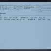
Bonnybridge, Motte, NS87NW 2, Ordnance Survey index card, page number 1, Recto |
c. 1958 |
Item Level |
|
 |
On-line Digital Images |
SC 2432105 |
Records of the Ordnance Survey, Southampton, Hampshire, England |
Bonnybridge, Motte, NS87NW 2, Ordnance Survey index card, page number 2, Recto |
c. 1958 |
Item Level |
|
 |
On-line Digital Images |
SC 2432106 |
Records of the Ordnance Survey, Southampton, Hampshire, England |
Bonnybridge, Motte, NS87NW 2, Ordnance Survey index card, Recto |
c. 1958 |
Item Level |
|
 |
On-line Digital Images |
SC 2432107 |
Records of the Ordnance Survey, Southampton, Hampshire, England |
Bonnybridge, Motte, NS87NW 2, Ordnance Survey index card, Recto |
c. 1958 |
Item Level |
|
 |
On-line Digital Images |
SC 2432108 |
Records of the Ordnance Survey, Southampton, Hampshire, England |
Bonnybridge, Motte, NS87NW 2, Ordnance Survey index card, page number 1, Recto |
c. 1958 |
Item Level |
|
 |
On-line Digital Images |
SC 2432109 |
Records of the Ordnance Survey, Southampton, Hampshire, England |
Bonnybridge, Motte, NS87NW 2, Ordnance Survey index card, page number 2, Recto |
c. 1958 |
Item Level |
|
|
All Other |
551 166/1/1 |
Records of the Ordnance Survey, Southampton, Hampshire, England |
Archaeological site card index ('495' cards) |
1947 |
Sub-Group Level |
|


