
Bonnybridge, Motte


Motte (Medieval)
Site Name Bonnybridge, Motte
Classification Motte (Medieval)
Alternative Name(s) Motte Of Seabegs; 'lie Mot De Seybeggis'; Antonine Primary School
Canmore ID 46798
Site Number NS87NW 2
NGR NS 82441 79812
Datum OSGB36 - NGR
Permalink http://canmore.org.uk/site/46798


- Council Falkirk
- Parish Falkirk
- Former Region Central
- Former District Falkirk
- Former County Stirlingshire
NS87NW 2 82441 79812
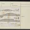
(NS 8243 7980) Motte (NR)
OS 6" map (1967).
Location formerly entered as NS 8243 7980.
See also NS87NW 32.00.
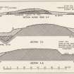
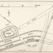
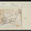
This motte is in an advanced state of decay. It was excavated in 1933 when it consisted of a rectangular mound 100' E-W by 70'. In 1933 it stood 11' above ground level. It was bordered on the S side by the Antonine Ditch and on the other three sides by a ditch, 17' wide and 6' deep. The mound consisted of a slight natural knoll, rising about 6' above the general ground level, to which a layer of clay soil about 5' in depth had been added. Amongst the few relics found was an unstratified pottery fragment dated to c.1200.
The motte is referred to as 'lie Mot de Seybeggis' in a charter of 1542, while in 1797 it was known as the 'Mote'.
S Smith 1934; RCAHMS 1963, visited 1953.
The mutilated remains of this motte stand in an area of waste ground.
Visited by OS (JP) 17 January 1974
The mutilated remains of this motte are situated immediately outside the perimeter fence of disused industrial premises. It appears as a roughly oval mound with no visible traces of the surrounding ditch identified during excavation in 1933.
Visited by RCAHMS (PC) 9 September 1983.
Scheduled, with portion of Antonine Wall (NS87NW 32).
Information from RCAHMS (RJCM), 20 November 2006.
Scheduled with length of Antonine Wall [NS87NW 32.00] '75m SW of Antonine Primary School' [NS87NW 73] (Scheduling number 12373).
Information from Historic Scotland, scheduling document dated 26 November 2009.
Excavation (1933)
NS 8244 7981 Area of trenching; 1 of at least 2, section through Antonine Wall, Ditch 42' wide and 12' deep. Area of trenching; 2 of at least 2, section through Antonine Wall, Ditch 50' wide, Berm 18' wide, stone Rampart 14' wide, superstructure almost entirely disappeared. Mound is a Motte.
Field Visit (July 1977)
Bonnybridge NS 824 798 NS87NW 2
Rectangular mound measuring 30m from W to E by 20m transversely at base and standing 3m above ground-level; occupies top of small natural knoll immediately N of Antonine Wall.
RCAHMS 1978, visited July 1977
(Smith 1934; RCAHMS 1963, p. 173, No. 180; Simpson and Webster 1972, 184, no. 225)

