
Seabegs Wood


Fortlet (Roman)
Site Name Seabegs Wood
Classification Fortlet (Roman)
Alternative Name(s) Antonine Wall; Dalnair
Canmore ID 46788
Site Number NS87NW 10
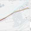
NGR NS 81166 79206
Datum OSGB36 - NGR
Permalink http://canmore.org.uk/site/46788


- Council Falkirk
- Parish Falkirk
- Former Region Central
- Former District Falkirk
- Former County Stirlingshire
NS87NW 10 81166 79206
See also NS87NW 9.
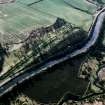
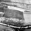
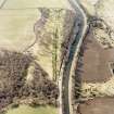
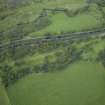
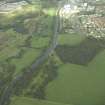
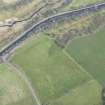
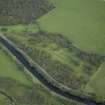
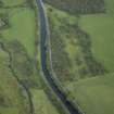
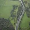
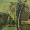
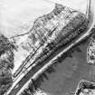
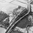
NS 812 792. A Roman fortlet attached to the Antonine Wall was discovered in June 1977 on the farm of Dalnair, at the west end of Seabegs Wood, in a field from which numerous fragments of Roman pottery have been recovered in recent years. The Antonine Wall makes a northward detour to include the plateau on which the fortlet is set, and itself forms the north rampart. The excavation, carried out under the auspices of the Hunterian Museum, revealed that the fortlet measured 21.8m N-S by 18m E-W internally and was defended by a rampart set on a stone base 3m wide and by two ditches. Parts of the east and south rampart base had been removed by ploughing. Examination of the NE and NW corners of the fortlet established that it and the Wall were of one build. The ditches on the east side were identified as being 3m (inner) and 1.6m wide, but they merged together and terminated close to the SE corner of the fortlet. The western ditches are assumed to have done the same. The lack of cover for the south rampart may be ascribed to the proximity of the Military Way, whose presumed line was sectioned as it emerged from Seabegs Wood. Only scattered cobbles and a possible drainage ditch were observed. There were gateways in both the north and south walls of the fortlet, each 3m wide and flanked by post holes. A roadway of rammed pebbles and small stones passed through the south gate to join the Military Way, and a similar road passed through the north gate, but examination failed to reveal evidence of its having crossed the Antonine Wall ditch. There was evidence of a second phase of occupation which involved changes which may have included the blocking of the north gate, but there was no evidence of re-cutting of the ditches. The interior of the fortlet was not examined.
L J F Keppie and J J Walker 1977; 1979; R Goodburn 1978.
NS 812 792. Further small finds from this fortlet include numerous pottery sherds and ten red-clay gaming balls.
DES (Small finds) 1977.
NS 8116 7921. There is no surface evidence of this fortlet in an arable field.
Site surveyed at 1:2500
Visited by OS (MJF) 24 May 1980.
NS 815 793 A watching brief was undertaken in March 2001 during minor excavations within the Scheduled area of the Antonine Wall, just to the E of Seabegs Roman fort, just to the S of the military way. This small-scale excavation revealed nothing of archaeological significance.
Sponsor: Historic Scotland
D Murray and G Ewart 2001
NS 8118 7924 Archaeological monitoring was undertaken in March 2003 during excavations intended to improve drainage of the ditch at the W end of the well-preserved section of the Antonine Wall. No features or finds of archaeological significance were uncovered.
Archive to be deposited in the NMRS.
Sponsor: HS
G Ewart 2003.
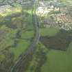
The length of the Antonine Wall (NS87NW 32.00) between Dalnair and Seabegs Wood [NS 8095 7908 to NS 8118 7922] has been scheduled, together with Dalnair temporary camp (NS87NW 9) and Seabegs fortlet (NS87NW 10).
Information from Historic Scotland, scheduling document dated 10 February 2005.
Field Visit (20 March 1957)
NS87NW c. 817 794 (unnoted)
Roman Fort, Seabegs (site)
Between Rough Castle and Castlecary, 3 ½ miles further west, there are no superficial indications of a fort. But as this gap is nearly twice as long as the normal interval, there can be no doubt that it was once bridged by an intermediate station situated somewhere in the vicinity of Seabegs. The most likely position for such as fort is at the east end of Seabegs Wood where some remains of fortifications are, in fact, said to have been visible at the end of the 17th century (R Sibbald 1707, 30). Here, between the wood and Seabegs Place, there is an elevated plateau which is admirably adapted for the purpose, with a steep scarp to the N, and commanding a wide view northwards across the Bonny Water and eastwards and westwards along the Wall. Horsley (J Horsley 1732, 171), on the other hand, ignores this site and refers instead to ‘some ruins that possibly may be the remains of a station’ at Dick's House, a village long since demolished, ¼ mile E of Seabegs Place. The latter site is, however, inferior from the tactical point of view since it lies in a hollow, while considerations of spacing are also entirely in favour of Seabegs (G Macdonald 1934, 239-40).
RCAHMS 1963, visited 20 March 1957.
Aerial Photography (1971)
Casual Observation (June 1977)
NS 812 792. A Roman fortlet attached to the Antonine Wall was discovered in June 1977 on the farm of Dalnair, at the west end of Seabegs Wood, in a field from which numerous fragments of Roman pottery have been recovered in recent years. The Antonine Wall makes a northward detour to include the plateau on which the fortlet is set, and itself forms the north rampart.
Excavation (1977 - 1978)
NS 812 792. A Roman fortlet attached to the Antonine Wall was discovered in June 1977 on the farm of Dalnair, at the west end of Seabegs Wood, in a field from which numerous fragments of Roman pottery have been recovered in recent years. The Antonine Wall makes a northward detour to include the plateau on which the fortlet is set, and itself forms the north rampart. The excavation, carried out under the auspices of the Hunterian Museum, revealed that the fortlet measured 21.8m N-S by 18m E-W internally and was defended by a rampart set on a stone base 3m wide and by two ditches. Parts of the east and south rampart base had been removed by ploughing. Examination of the NE and NW corners of the fortlet established that it and the Wall were of one build. The ditches on the east side were identified as being 3m (inner) and 1.6m wide, but they merged together and terminated close to the SE corner of the fortlet. The western ditches are assumed to have done the same. The lack of cover for the south rampart may be ascribed to the proximity of the Military Way, whose presumed line was sectioned as it emerged from Seabegs Wood. Only scattered cobbles and a possible drainage ditch were observed. There were gateways in both the north and south walls of the fortlet, each 3m wide and flanked by post holes. A roadway of rammed pebbles and small stones passed through the south gate to join the Military Way, and a similar road passed through the north gate, but examination failed to reveal evidence of its having crossed the Antonine Wall ditch. There was evidence of a second phase of occupation which involved changes which may have included the blocking of the north gate, but there was no evidence of re-cutting of the ditches. The interior of the fortlet was not examined.
L J F Keppie and J J Walker 1977; 1979; R Goodburn 1978.
Note (1978)
Seabegs wood, Roman fortlet NS 812 792 NS87NW
A fortlet built integral with the Wall, was partially excavated in 1977.
RCAHMS 1978
Field Visit (24 May 1980)
NS 8116 7921. There is no surface evidence of this fortlet in an arable field.
Site surveyed at 1:2500
Visited by OS (MJF) 24 May 1980.
Ground Survey (24 May 1980)
NS 8116 7921. There is no surface evidence of this fortlet in an arable field.
Site surveyed at 1:2500
Visited by OS (MJF) 24 May 1980.
Watching Brief (28 March 2001 - 29 March 2001)
NS 815 793 A watching brief was undertaken by Kirkdale Archaeology of a small excavation within the scheduled area of the Antonine Wall, just to the E of Seabegs Roman Fort, on the 29th of March, 2001. The aim was to dig a small hole, to take a signpost, in a location already chosen by Historic Scotland just to the S of the Military Way (Figs. 1 & 2). The Antonine Wall survives here, for a short distance, as an impressive upstanding monument, with the wall, ditch and its’ upcast, and the Military Way all clearly recognisable. This excavation revealed nothing of archaeological significance.
Sponsor: Historic Scotland
D Murray and G Ewart 2001
Kirkdale Archaeology
Watching Brief (March 2003)
NS 8118 7924 Archaeological monitoring was undertaken in March 2003 during excavations intended to improve drainage of the ditch at the W end of the well-preserved section of the Antonine Wall. No features or finds of archaeological significance were uncovered.
Archive to be deposited in the NMRS.
Sponsor: HS
G Ewart 2003.
Ground Survey (27 June 2006)
Publication Account (2008)
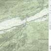
A 1:25000 scale map of the Antonine Wall was published by RCAHMS in 2008. The map shows the course of the Antonine Wall on a modern map base, including areas where the Wall is in public ownership or care and can be visited. The data had been collated as part of the project to prepare maps for the World Heritage Site nomination bid.

