
Following the launch of trove.scot in February 2025 we are now planning the retiral of some of our webservices. Canmore will be switched off on 24th June 2025. Information about the closure can be found on the HES website: Retiral of HES web services | Historic Environment Scotland
Craignethan Castle


Castle (16th Century)
Site Name Craignethan Castle
Classification Castle (16th Century)
Alternative Name(s) Craignethan House; Tillietudlem Castle; River Nethan
Canmore ID 46563
Site Number NS84NW 3
NGR NS 81618 46347
Datum OSGB36 - NGR
Permalink http://canmore.org.uk/site/46563


First 100 images shown. See the Collections panel (below) for a link to all digital images.
- Council South Lanarkshire
- Parish Lesmahagow
- Former Region Strathclyde
- Former District Clydesdale
- Former County Lanarkshire
NS84NW 3 81618 46347.
(NS 8158 4635) Craignethan Castle (NR)
(Ruins)
OS 6" map (1913)
The oldest part of the castle is undoubtedly the keep. The house in the south-west angle of the enclosure was built in 1665. This is the castle immortalised by Sir Walter Scott as 'Tillietudlem Castle'.
D MacGibbon and T Ross 1887
The keep is in a good state of repair, as is the 17th century house at the south-west and its surrounding walls. The whole fabric is undergoing extensive repairs by the Ministry of Works.
Visited by OS (JFC) 18 March 1954
Craignethan Castle - 16th century tower with 17th century additions.
W D Simpson 1959; S Cruden 1960
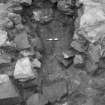
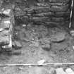
In 1984 a clay-bonded, rubble-built kiln was uncovered within the basement of the castle's NE tower. By 1992 the kiln had deteriorated so badly that there was little alternative but to fully excavate its remaining fabric. Its bottom course comprised a skin of rubble enclosing smaller masonry, the inside arc of which was set into the underlying boulder clay. Part of the kiln had been built over a cobbled floor that was contemporary with the chamber's original usage as a kitchen. There was no metal-working debris near to the kiln, suggesting that the room had either continued as a kitchen or had been converted into a bakery or a brewhouse.
Sponsor: Historic Scotland
J Lewis 1992.
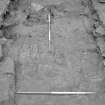
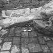
The area bounded by the castle's NE and SE towers, the E curtain wall and the 16th-century tower house is covered by concrete which forms a cap over a series of vaulted cellars below and which slopes down to the W towards the tower house. Because of water seepage into the cellars, the concrete is to be removed and the underlying masonry consolidated. Exploratory trenches were excavated within this area by Scotia Archaeology Limited to assess the nature and extent of the archaeological deposits therein.
The main trench, measuring 7.0m E to W by 2.0m N to S spanned most of the width of the area between the curtain wall and the tower house. Features exposed included the top of the wall that divides the underlying cellars from an accessing passage; the crown of the vault of one of the cellars to the E of the wall; and a flagged surface, which appears to have been repaired at some stage, between the newly exposed wall and the E wall of the tower house. Overlying the extrados of the vault was a compact layer of rubble set into very hard mortar, its depth increasing towards the curtain wall, perhaps to allow heavy guns to be placed thereon.
Sponsor: Historic Scotland
J Lewis 1993
NS 815 463 Following exploratory trenching in late 1993 (Lewis 1993), the entire area bounded by the E curtain wall, the tower house and the NE and SE towers was investigated by Scotia Archaeology Limited. This area, which measured 13m N-S by 7.5m E-W, overlay a series of vaulted cellars and a connecting passage into which rainwater had been seeping through the masonry and concrete capping above. The excavation preceded the consolidation of the masonry of the cellars.
Below the concrete and other recent deposits was a layer of substantial rubble set in hard mortar which overlay the extrados of the vaults, the rubble being deepest against the E curtain. Between the tower house and the top of the E wall of the passage was a flagged path, probably contemporary with rectangular cobbles which extended around the N and S sides of the tower house.
Recent disturbances to the immediate W of the SE tower were probably associated with the demolition of a lean-to building. There was no positive evidence of the stair illustrated by D MacGibbon and T Ross (1887) as being against the N wall of the same tower.
Sponsor: Historic Scotland.
H Smith 1995.
The castle is visible on vertical air photographs, (OS 83/154/021-22, flown 1983).
Information from RCAHMS (DE) August 1996
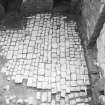
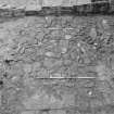
NS 8158 4635 A project to evaluate the possibility of reinstating a cobbled courtyard was undertaken in October 1998.
The events occurring after initial stone robbing seem to have involved a possible early levelling up of the courtyard to offset the removal of the cobble setts, followed at some stage by a major clearance of the wall-heads and possible subsequent levelling of waste soil across the site to create a level grassed courtyard. It was noted that finds from this material were both few in number and consisted of 18th and 19th-century material.
A final set of works appears to have involved a degree of excavation this century in the corners of the site in order to expose and lay out limited areas of the cobbles, as well as an attempt to find an old gatehouse in the vicinity of the S wall.
Sponsor: Historic Scotland
D Stewart 1998.
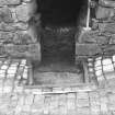
NS 8158 4635 A watching brief was undertaken during the excavation of a drainage trench along the base of the N section of the outer face of the outer courtyard wall (NMRS NS84NW 3). An area of high-quality basalt setts, along with a worn threshold slab apparently associated with a blocked doorway in the courtyard wall were located 4m S of the doocot. The threshold and setts represent an earlier entrance to the outer courtyard.
Sponsor: Historic Scotland
D Stewart 2000.
NS 815 463 A watching brief was undertaken in January 2002 while five shallow trenches were excavated within the compound immediately outside the N wall of the outer courtyard. These had a maximum depth of 25cm and revealed nothing of archaeological significance.
Archive to be deposited in the NMRS.
Sponsor: HS
G Ewart and J Franklin 2002
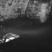
NS 815 463 The top 1.35m of the fill of the well within the keep of Craignethan Castle was removed to insert lighting. This revealed five courses of high-quality ashlar masonry, with no sign of a bottom to the well. The fill was found to be deliberate mid-20th-century infill with later rubbish accumulation.
Archive to be deposited in the NMRS.
Sponsor: HS
G Ewart and D Murray 2002
NS 815 463 Turf and topsoil were removed from an area totalling 57m in length around the S and E sides of Craignethan Castle in January and February 2003. An area of rough metalling was found directly facing the main entrance, probably the remains of an earlier access path. Also found was an area covered in demolition debris, possibly evidence of levelling work or stone robbing.
Archive to be deposited in the NMRS.
Sponsor: HS
G Ewart 2003
NS 815 463 An evaluation was undertaken in January 2004 to determine the extent of the buried cobbled courtyard surface known to lie against the W side of the tower (see DES 1998, 91), and to monitor the cutting of a new drain trench from the N wall of the tower to the edge of the nearby gorge, a continuation of work carried out last year (DES 2003, 126).
The interpretation of the sequences located in the courtyard evaluation indicate the presence of a finely constructed cobbled surface, seen to the N and S of the tower as well as occupying all of the courtyard to the W of the tower.
A shallow trench within the confines of the courtyard N wall revealed only a sandy clay levelling horizon, presumably related to the original stone surface. A deep narrow trench through the N courtyard wall revealed the full shape of the cut, but showed no sign of a constructed doorway in this part of the wall.
Further archaeological monitoring was undertaken during two minor excavations in May 2004. The first involved the site of new cycle racks to be positioned to the NW of the outer courtyard next to an existing car park. The second was to clear out remaining sediment in the partly exposed stone-lined drain running along the N side of the tower in an area of newly laid setts. The latter revealed the fine quality of the old stone-lined box drain, which may well have drained a level represented by the buried cobble surface known to exist below the present turfed-over courtyard. The insertion of the W transverse wall broke through this drain, rendering it useless. However, the depth of debris over the NE corner of the courtyard (over 500mm in places - possibly a levelling-up process against the W wall) necessitated a higher-level drain which was consequently made an integral part of the W transverse wall construction, draining down into the severed end of the older drain below.
Archive to be deposited in the NMRS.
Sponsor: HS.
D Stewart 2004
Watching brief NS 8153 4635 A watching brief was undertaken in March 2005 during the excavation of 14 post-pits for new railings in the outer courtyard of the castle (NS84NW 3), at the far W side near the main entrance doorway. Five pits were cut on an E-W line from the N side of the entrance, to a point 6.3m to the E where this line would link to the N end of a N-S line of nine further pits with a length of 11.6m. Total length of pit lines - 17.9m.
The area of the work ran down the N and E sides of a modern footpath which may well have disturbed the adjacent surface levels. In particular, an area of cobblestones along the E side of the footpath looked modern.
It is known from previous work (DES 2003, 126) that the inner and outer courtyards of Craignethan Castle were originally paved with an extensive surface of cut basalt paving blocks, which now only survive in part below the modern turf and topsoil. These works indicated that residual patches of paving blocks still exist to the N of the gateway, with the two lines of pits revealing the extent of the robbing. The layers in the empty pits merely exhibited late levelling debris over a natural clay, silt and pebble-rich subsoil.
Archive to be deposited in NMRS.
Sponsor: HS.
D Stewart 2005
NS84NW 3.00 81618 46347.
NS84NW 3.01 c. 81550 46360 Sundial (possible).
NMRS REFERENCE
M. O.P. B. & W GUARDIANSHIP
NMRS Complement de Walter Scott, Guide Pictoresque du Voyageur en Ecosse 1838, Engraving p. 254.
EXTERNAL REFERENCE
National Library
Border Magazine, September 1898 - article and photographs
Photographic Record (1865 - 1867)
Photograph album with photos compiled and photographed by J McGhie, Hamilton.
Aerial Photography (August 1970)
Oblique aerial photographs of Craignethan Castle, Lanarkshire, taken by John Dewar in August 1970.
Publication Account (1985)
The development of artillery in the later middle ages rendered the defences of many of the earlier castles obsolete, and expensive or difficult alterations were necessary in order to give them sufficient strength to withstand a determined attack.A more radical solution to this problem was to build from scratch on a new site, and this was the case at Craignethan where Sir James Hamilton of Finnart built a stronghold for the Hamilton family. Sir James was the illegitimate son of the 1st Earl of Arran, and after travelling on the continent he returned to play his part in family affairs.While in Italy he had observed the rapid development of new styles of artillery fortification and, once back in Scotland, put his new found knowledge to practical use (see also no. 30 for Sir James' alterations at Blackness Castle). Work on the castle began in the 1530s, with major additions being made before 1579; after it had gone out of use as a defensive structure, a laird's house was built in the outer courtyard.
The choice of this particular site for the castle is curious, for although it occupies the tip of a steepsided promontory with good natural defence on three sides, the remaining flank is overlooked by higher ground which gave any assailant considerable advantage. In the earliest phase, the castle comprised a large tower-house surrounded by a walled enclosure (the barmkin) with the added protection of a dry ditch drawn across the neck of the promontory. The design is essentially medieval in character, but two features point to the future. In the first place, the exposed west wall (now reduced to its foundations but its original proportions can be seen in a reconstruction drawing in the site museum) was built on a massive scale in order to withstand an artillery barrage. The most novel feature of the plan, however, was the construction of a caponier at the south end of the ditch. This device, probably first seen by Sir James during his travels in Italy, was cunningly concealed in the base of the deep ditch and provided a stronghold from which the defenders could rake the length of the ditch with small-arms fire (for another example see Stirling Castle, no. 3G). Soon after the construction of the early work the castle was extended by the addition of a walled courtyard attached to the outer side of the ditch.
Craignethan's role as a defensive work ended in 1579 when it was partially demolished following the disgrace of the Hamilton family. In 1G59 it was bought by the Convenantor, Andrew Hay, who built a house in the south-west angle of the outer courtyard. The house is now occupied by the custodian, and in one of the outbuildings there is a small site exhibition and museum.
Information from ‘Exploring Scotland’s Heritage: The Clyde Estuary and Central Region’, (1985).
Excavation (6 October 1998 - 9 October 1998)
A project to evaluate the possibility of reinstating a cobbled courtyard at Craignethan castle in Lanarkshire was undertaken by Kirkdale Archaeology over a four day period from the 6th to the 9th of October 1998.
The excavation seems to indicate that perhaps one third of the cobbling has now gone. However the setts that are left appear to be in good condition as might be expected from what appears to be basalt rock. Finally it can only be added that a degree of relaying would be necessary to produce a surface safe for walking on.
Sponsor: Historic Scotland
D Stewart 1998
Kirkdale Archaeology
Watching Brief (12 October 1999 - 20 October 1999)
A watching brief was undertaken at Craignethan Castle near Lanark while Historic Scotland personnel hand-dug a drainage trench along the base of the northern section of the outer face of the outer courtyard wall.
The trench measured 34m in length with a width of 400mm and a depth of 500mm, and commenced just to the N side of the entrance gateway in the centre of the outer courtyard wall, continuing along the base of the wall in a northerly direction towards the doocot. 3m short of the doocot the trench line branched out to the NW to link up with an existing manhole 4m due W of the doocot.
The principal discovery during this operation was the uncovering of an area of good quality basalt setts, along with a worn threshold slab apparently associated with a blocked doorway in the courtyard wall positioned 4m S of the doocot.
Sponsor: Historic Scotland
Kirkdale Archaeology
Watching Brief (15 August 2001 - 16 August 2001)
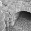
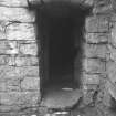
Under its call-off contract with Historic Scotland, Kirkdale Archaeology were asked to monitor the removal of the fill of a well, located within Craignethan Castle. The Castle is an outstanding example of a late medieval artillery defence, standing on a steep promontory above the river Nethan, a tributary of the Clyde, approachable only from the W. The Castle takes the form of an outer and inner courtyard, separated by a large ditch and a (now severely reduced) massive wall, with an oblong keep within the inner courtyard.
At the end of the excavation a depth of 2.7m below floor level had been reached, meaning that approximately 1.35m of fill was removed. Five courses of high quality ashlar masonry had been revealed, with no sign of the bottom of the well. The excavation of this well demonstrates that at least the upper fill of this feature is 20th century in origin.
Sponsor: Historic Scotland
G Ewart & D Murray 2001
Kirkdale Archaeology
Excavation (21 January 2002)
NS 815 463 A watching brief was undertaken in January2002 while five shallow trenches were excavated within the compound immediately outside the N wall of the outer courtyard.These had a maximum depth of 25cm and revealed nothing of archaeological significance.
G Ewart and J Franklin 2002
Sponsor: Historic Scotland
Kirkdale Archaeology
Watching Brief (27 January 2003 - 19 February 2003)
Under the terms of its P.I.C. call-out contract with Historic Scotland, Kirkdale Archaeology was asked to undertake a programme of archaeological monitoring during minor excavations at Craignethan Castle from 27/1/2003 – 19/2/2003.
The area of the works consisted of an open cobbled space at the base of the N wall of the main tower. The area is defined to the N by an extension to the Inner Courtyard wall, to the W by a traverse wall and to the E by steps down into the NE tower. The whole cobbled surface measured 12.90m EW by 4.50m NS, and is notable for an obvious slope towards the E.
The works comprised the uplifting of the cobbles and the excavation of the bedding material below. It was expected that between 200mm and 300mm of late infill material would have to be excavated and barrowed out to skips situated at the castle front gate, a time consuming exercise made the more so by inclement weather. The nature of the features likely to be located during these operations was entirely conjectural.
This area of the castle appears to have been affected by recent excavations and landscaping work as well as by older alterations to the drainage system. The results of the earlier work give an insight into the changes of drainage practices in this castle.
G Ewart 2003
Sponsor: Historic Scotland
Kirkdale Archaeology
Excavation (13 January 2004 - 5 May 2004)
NS 815 463 An evaluation was undertaken in January 2004 to determine the extent of the buried cobbled courtyard surface known to lie against the W side of the tower (see DES 1998, 91), and to monitor the cutting of a new drain trench from the N wall of the tower to the edge of the nearby gorge, a continuation of work carried out last year (DES 2003, 126).
The interpretation of the sequences located in the courtyard evaluation indicate the presence of a finely constructed cobbled surface, seen to the N and S of the tower as well as occupying all of the courtyard to the W of the tower.
A shallow trench within the confines of the courtyard N wall revealed only a sandy clay levelling horizon, presumably related to the original stone surface. A deep narrow trench through the N courtyard wall revealed the full shape of the cut, but showed no sign of a constructed doorway in this part of the wall.
Further archaeological monitoring was undertaken during two minor excavations in May 2004. The first involved the site of new cycle racks to be positioned to the NW of the outer courtyard next to an existing car park. The second was to clear out remaining sediment in the partly exposed stone-lined drain running along the N side of the tower in an area of newly laid setts. The latter revealed the fine quality of the old stone-lined box drain, which may well have drained a level represented by the buried cobble surface known to exist below the present turfed-over courtyard. The insertion of the W transverse wall broke through this drain, rendering it useless. However, the depth of debris over the NE corner of the courtyard (over 500mm in places - possibly a levelling-up process against the W wall) necessitated a higher-level drain which was consequently made an integral part of the W transverse wall construction, draining down into the severed end of the older drain below.
D Stewart 2004
Sponsor: Historic Scotland
Kirkdale Archaeology
Watching Brief (15 March 2005 - 16 March 2005)
NS 8153 4635 A watching brief was undertaken in March 2005 during the excavation of 14 post-pits for new railings in the outer courtyard of the castle (NS84NW 3), at the far W side near the main entrance doorway. Five pits were cut on an E–W line from the N side of the entrance, to a point 6.3m to the E where this line would link to the N end of a N–S line of nine further pits with a length of 11.6m. Total length of pit lines – 17.9m. The area of the work ran down the N and E sides of a modern footpath which may well have disturbed the adjacent surface levels. In particular, an area of cobblestones along the E side of the footpath looked modern.
It is known from previous work (DES 2003, 126) that the inner and outer courtyards of Craignethan Castle were originally paved with an extensive surface of cut basalt paving blocks, which now only survive in part below the modern turf and topsoil. These works indicated that residual patches of paving blocks still exist to the N of the gateway, with the two lines of pits revealing the extent of the robbing. The layers in the empty pits merely exhibited late levelling debris over a natural clay, silt and pebble-rich subsoil.
D Stewart 2005
Sponsor: Historic Scotland
Kirkdale Archaeology
Watching Brief (16 December 2008)
NS 8161 4635 A small trench was excavated in the basement of Craignethan Castle on 16 December 2008 to allow the insertion of a concrete base for a new handrail for the existing steps. Modern deposits of gravel and bedding overlay mortar debris, probably from the stair’s construction, under which there was a compact layer of imported clay.
Archive: RCAHMS (intended)
Funder: Historic Scotland
Information from OASIS ID: kirkdale1-249668 (D Murray) 2008
Watching Brief (14 March 2012 - 16 March 2012)
NS 8164 4635 A watching brief was undertaken 14 – 16 March 2012 during the excavation of trenches for a new fence and shrubs. No finds or features of archaeological significance were recorded.
NS 8148 4633 (centred on) A watching brief was undertaken on 14 March 2012 during the excavation of trenches for new signs. The deposits recorded in most of the trenches indicated that the area W of the castle had been heavily landscaped in the modern period. There was some indication that older landscaping features may underlie these deposits and a surface of laid stone recorded in one trench may merit further investigation.
Archive: RCAHMS (intended)
Funder: Historic Scotland
Paul Fox, Kirkdale Archaeology
2012
Watching Brief (5 September 2013)
NS 816 463 A watching brief was undertaken on 5 September 2013 during the installation of a new sign for Nethan Gorge. A rectangular slot aligned SW–NE and measuring 0.3 x 1m and 700mm in depth was excavated. The topsoil consisted of a c230mm deep mid to pale brown very fine silt overlying a brownish orange very sandy silt. Two large stones, one with a flat upper surface and one with a flat upper surface and outer face, were located at the NE end of the slot at a depth of 220mm. This feature extended the width of the trench and was 100mm high. The limited nature of the excavation made it difficult to ascertain the function of the feature, but it is possible that they represent the ephemeral remains of either a wall or the base of a wall.
Archive: RCAHMS. Report: Historic Scotland
Funder: Sandblast Sign Company
Rebecca Shaw, Rebecca Shaw Archaeological Services, 2013
(Source: DES)
Excavation (February 2019)
NS 81638 46331 An excavation took place, February 2019, to investigate the nature and depth of the foundations of the SE corner tower. Two test pits were excavated and it was found that the walls extended to 0.55-0.7m below the existing ground surface.
Archive: NRHE (intended). Reports lodged with South Lanarkshire Council SMR
Funder: Historic Environment Scotland
Bethan Gray - CFA Archaeology Ltd
(Source: DES Vol 20)

