|
Manuscripts |
MS 5156/1 |
Historic Scotland Archive Project |
Survey Archive: List of sites and associated APs from Millbank to Nether Abington, along the proposed line of the M74 motorway. |
1990 |
Item Level |
|
|
Manuscripts |
MS 5156/4 |
Historic Scotland Archive Project |
Survey Archive: Location plan of sites surveyed between Millbankand Nether Abington along the line of the proposed M74 motorway. Site numbers do not match sites listed in MS 5156/2. |
2/1990 |
Item Level |
|
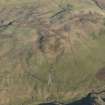 |
On-line Digital Images |
DP 084523 |
RCAHMS Aerial Photography Digital |
General oblique aerial vew of the remains of the farmstead, field boundaries, platform and rig, taken from the W. |
8/11/2009 |
Item Level |
|
 |
On-line Digital Images |
SC 2431623 |
Records of the Ordnance Survey, Southampton, Hampshire, England |
Cuff Hill, NS83SE 14, Ordnance Survey index card, Recto |
c. 1958 |
Item Level |
|
|
Prints and Drawings |
BD 132/1 |
Historic Scotland Archive Project |
Survey drawings: Field drawings from M74 survey - Millbank to Abington |
2/1990 |
Batch Level |
|
|
All Other |
551 166/1/1 |
Records of the Ordnance Survey, Southampton, Hampshire, England |
Archaeological site card index ('495' cards) |
1947 |
Sub-Group Level |
|


