
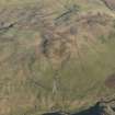
Cuff Hill


Farmstead (Period Unassigned)
Site Name Cuff Hill
Classification Farmstead (Period Unassigned)
Canmore ID 46509
Site Number NS83SE 14
NGR NS 8651 3110
Datum OSGB36 - NGR
Permalink http://canmore.org.uk/site/46509


- Council South Lanarkshire
- Parish Douglas
- Former Region Strathclyde
- Former District Clydesdale
- Former County Lanarkshire
NS83SE 14 8651 3110
Probable eighteenth century farm: remains of two buildings and an enclosure.
Visited by OS(WDJ) 8 December 1959.
Site recorded during an archaeological evaluation conducted on 30 alternative route elements, with a combined length of c84km, for a proposed road linking the M8 near Whitburn, Lothian Region with the M6/M74 near Douglas, Clydesdale District.
NS83SE 14 Deserted settlement of Old Cot
An illustrated report will be deposited with the NMRS.
Sponsor: Roads Directorate of The Scottish Office Industry Department, managed on its behalf by Historic Scotland.
A J Dunwell and R J Strachan 1995.
Geophysical Survey (February 1990)
Detailed survey of several sites in the area prior to the M74 motorway.

