|
Prints and Drawings |
MS 120/1 |
|
Loubcroy & Ledmore Estates, Ross & Cromarty/Sutherland. J.M Howell Field Survey 1976. Manuscript Copy of published report. 1976 |
|
Item Level |
|
|
Prints and Drawings |
RCD 115/1 |
|
Survey Area Location Map Dyeline copy (2 copies) |
1976 |
Item Level |
|
|
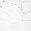
Prints and Drawings |
RCD 115/2 P |
|
Survey Area - General Monument Location (p68 Published report) Ink on paper 1976 |
|
Item Level |
|
|
Prints and Drawings |
RCD 115/3 |
|
Location (p68 Published report) Ink on paper |
1976 |
Item Level |
|
|
Prints and Drawings |
RCD 115/6 P |
|
Plan of Mon. LOU 44 Ink on paper |
1976 |
Item Level |
|
|
Prints and Drawings |
RCD 115/7 |
|
Plan of Mon. LOU 44 Dyeline Copy |
1976 |
Item Level |
|
 |
On-line Digital Images |
SC 1926321 |
|
Plan of Mon. LOU 44 Ink on paper |
1976 |
Item Level |
|
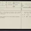 |
On-line Digital Images |
SC 2346321 |
Records of the Ordnance Survey, Southampton, Hampshire, England |
Loch Borralan, NC21SE 8, Ordnance Survey index card, page number 1, Recto |
c. 1958 |
Item Level |
|
 |
On-line Digital Images |
SC 2346322 |
Records of the Ordnance Survey, Southampton, Hampshire, England |
Loch Borralan, NC21SE 8, Ordnance Survey index card, Recto |
c. 1958 |
Item Level |
|
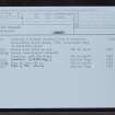 |
On-line Digital Images |
SC 2346323 |
Records of the Ordnance Survey, Southampton, Hampshire, England |
Loch Borralan, NC21SE 8, Ordnance Survey index card, Recto |
c. 1958 |
Item Level |
|
|
All Other |
551 166/1/1 |
Records of the Ordnance Survey, Southampton, Hampshire, England |
Archaeological site card index ('495' cards) |
1947 |
Sub-Group Level |
|


