
Loch Borralan


Enclosure (Period Unassigned)
Site Name Loch Borralan
Classification Enclosure (Period Unassigned)
Canmore ID 4632
Site Number NC21SE 8
NGR NC 26435 10844
Datum OSGB36 - NGR
Permalink http://canmore.org.uk/site/4632


- Council Highland
- Parish Assynt
- Former Region Highland
- Former District Sutherland
- Former County Sutherland
NC21SE 8 2644 1084.
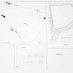
(NC 2644 1084) A sub-circular enclosure, 16m in diameter with walls 0.5m in both width and height, lies on the edge of Loch Borralan.
J M Howell 1976, No. 44 (see archive MS/120/1)
The turf-covered remains of an early modern enclosure as planned by Howell (see archive MS/120/1)
Visited by OS (N K B) 23 June 1980.
Field Visit (23 November 2009)
A series of turf covered banks forming an enclosure adjacent to Loch Borralan are located on a small promontory. Dimensions average 11m by 6m, aligned E/W. No obvious function of these banks could be determined, nor is their any indication of probable date.
(HLP_no 1)
Assynt's Hidden Lives Project 2009

