
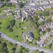
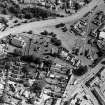
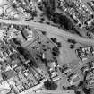
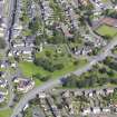
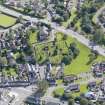
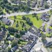
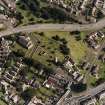
Stirling, Kirk Wynd, St Ninian's Old Parish Church, Churchyard


Burial Enclosure (18th Century), Churchyard (17th Century), Cross Slab(S) (Early Medieval), Gate Pier (18th Century)
Site Name Stirling, Kirk Wynd, St Ninian's Old Parish Church, Churchyard
Classification Burial Enclosure (18th Century), Churchyard (17th Century), Cross Slab(S) (Early Medieval), Gate Pier (18th Century)
Canmore ID 46228
Site Number NS79SE 44.01
NGR NS 79590 91678
Datum OSGB36 - NGR
Permalink http://canmore.org.uk/site/46228


- Council Stirling
- Parish Stirling
- Former Region Central
- Former District Stirling
- Former County Stirlingshire
NS79SE 44.01 79590 91678
NS 796 917. Tombstones: (i) Twenty-three yards SW of the buttress on the S side of the choir of the old parish church, and 8 yds N of the S boundary wall of the old churchyard there is a stone, 1'4" in height by 1'2" in breadth. A cross with wedge-shaped arms and a hollowed centre is roughly carved in relief on both sides of the stones and on its upper surface there is a set of incised initials. This stone resembles one from Hoddam which has been ascribed by Radford (1954) to the 10th or 11th century; but there is no evidence, apart, perhaps, from the place- name Eccles itself, for a church at St Ninians at such an early date. The initials were no doubt added in the 17th or 18th century when the stone was re-used. (ii) Fifteen yards NW of the NW angle of the choir, there is a headstone, 1'11" x 1'10". A small incised cross is carved on one side. The stone is probably of medieval date, but its present position suggests that it has been cut down and re-used in post-Reformation times.
RCAHMS 1963, visited 1955
(i) at NS 7959 9166; (ii) at NS 7959 9169. Both these stones are as described. (i) is very mutilated but it is doubtful if it is as early as the 10th/11th century.
Surveyed at 1:1250.
Visited by OS (JP) 19 December 1973
EXTERNAL REFERENCE:
Scottish Record Office
Division of seats & burial places amongst the heritors.
1639 GD97/3/109
Vol. Duntreath Muniments.
Fine enclosing walls and gates, fluted and rusticated piers with ball finials on W archway on E 2-stones of mediaeval date, one an early cross; good collection from 17th century onwards. (Historic Scotland)

