
Stirling, Causewayhead, Bridgehaugh Road, Old Bridge


Road Bridge (15th Century)
Site Name Stirling, Causewayhead, Bridgehaugh Road, Old Bridge
Classification Road Bridge (15th Century)
Alternative Name(s) River Forth; Stirling Old Bridge; Stirling Bridge; Stirling, Forth Bridge; Old Drip Bridge
Canmore ID 46195
Site Number NS79SE 2
NGR NS 79701 94565
Datum OSGB36 - NGR
Permalink http://canmore.org.uk/site/46195


First 100 images shown. See the Collections panel (below) for a link to all digital images.
- Council Stirling
- Parish Stirling
- Former Region Central
- Former District Stirling
- Former County Stirlingshire
NS79SE 2.00 79701 94565
(NS 7970 9456) Bridge (NR)
OS 6" map, (1958).
NS79SE 2.01 NS 7975 9455 Watching Brief
For predecessor and successor bridges, see NS79SE 1 and NS79SE 185 respectively.
Location formerly entered as NS 79712 94568.
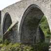
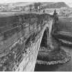
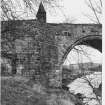
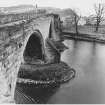
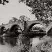
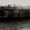
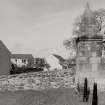
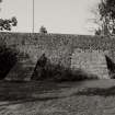
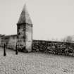
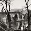
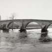
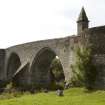
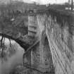
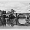
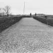
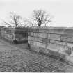
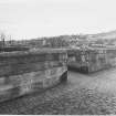
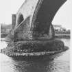
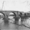
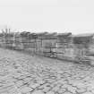
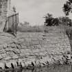
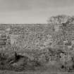
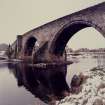
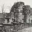
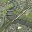
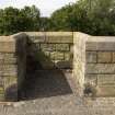
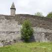
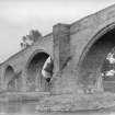
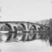
Though Simpson states that the Old Bridge was built between 1410 and 1415, the RCAHMS consider its appearance suggests a date in the 15th or early 16th century for its erection. (See also NS79SE 1). Built of squared rubble, it consists of four arches. References to the repair of the bridge in the 17th century are in the Burgh Council records. The southern arch was rebuilt in 1749, the original arch having been blown up in 1745 to prevent the Highland army entering Stirling. It was closed to wheeled traffic in 1831, when the new bridge was built (at NS 7973 9445). In good preservation, it is now under guardianship.
An excavation made in 1912 at the NE end of the bridge revealed three earlier causeways underlying the existing road; these no doubt represent attempts to ease the gradient of the access.
RCAHMS 1963, visited 1955; W D Simpson and S Piggott 1970.
The bridge is as described.
Visited by OS (JP) 6 December 1973.
(Location cited as NS 797 945). Old Bridge, 15th or 16th century, strengthened 1912-20. A particularly fine 4-span bridge with semicircular arches and triangular cutwaters; the bases of the piers are now protected by massive rubble. The arch rings are ashlar, as is some of the masonry in the spandrels. Now a Guardianship monument, and used as a footbridge only.
J R Hume 1976.
Bridge [NAR]
OS 1:10,000 map, 1982.
This site has only been partially upgraded for SCRAN. For further information, please consult the Architecture Catalogues for Stirling District.
March 1998.
Scheduled as 'Stirling Old Bridge... Stirling's late medieval bridge which spans the River Forth.'
Information from Historic Scotland, scheduling document dated 23 February 2004.
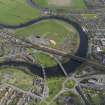
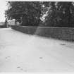
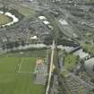
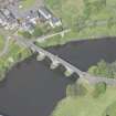
This bridge is situated in the Causewayhead area and formerly carried road traffic from Stirling to the NE across the River Forth, to the N of Stirling (NS79SE 154). It is now restricted to pedestrian traffic.
The location assigned to this record defines the mispoint of the structure. The available map evidence indicates that it extends from NS c. 79664 94554 to NS c. 79742 94577.
Information from RCAHMS (RJCM), 31 May 2006.
EXTERNAL REFERENCE:
Scottish Record Office:
Highlands have repaired the bridge.
Letter from John Graham of Dougalston to Mungo Graham of Gorthie.
1746 GD 220/5/1621/6
EXTERNAL REFERENCE:
National Library:
Country Life October 16th 1942
Country Life 1979.
(Undated) information in NMRS.
Publication Account (1985)
The Old Bridge at Stirling is the best preserved of the two surviving late medieval bridges in the former county of Stirling (the other being at Bannockburn, NS 807904). Until comparatively recent times, Stirling was the lowest bridging point on the Forth, and the town owed much of its importance in medieval times to the strategic value of this position. Like the houses of the earlier medieval town, the first bridges across the Forth were of wood (despite the misleading representation of a stone bridge on the burgh seal of 1296), and in 1905 the foundations of a wooden bridge were found in the river bed about 60 m upstream of the Old Bridge.
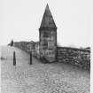
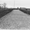
The present bridge, probably the first to be built of stone, dates from the late 15th century or early 16th century. It spans the river with four semicircular arches supported on piers with triangular cut-waters. On the sides of the carriageway there are refuges for pedestrians which, until the 18th century, were roofed. Originally the ends of the bridge were provided with archways, and the one on the north side of the river had an iron gate, but they were removed in the 18th century and replaced by small square pillars.
In 1745 one of the arches was cut on the orders of General Blakeney in order to prevent the Jacobite army from entering the town, but the damage was soon repaired and the bridge continued in use until 1831, when a new bridge was built about 100m downstream.
Information from ‘Exploring Scotland’s Heritage: The Clyde Estuary and Central Region’, (1985).
Project (2007)
This project was undertaken to input site information listed in 'Civil engineering heritage: Scotland - Lowlands and Borders' by R Paxton and J Shipway, 2007.
Publication Account (2007)
This strategically and historically significant bridge over the Forth at Stirling is at or near the site of a timber
bridge which was destroyed in the battle of 1297. The bridge, which probably replaced a ferry, is of coursed
masonry (Ballengiech stone) of good quality and workmanship, and possibly dates from as early as the 15th
century.
It is a tall and handsome structure, with four nearly semicircular arch spans of 38 ft, 55 ft, 56 ft and 48 ft from
south to north; the span sizes being determined by the foundation conditions, often the case with mediaeval
bridges. The bridge piers are 14 ft 9 in. thick and there is a slight bend in the line of the bridge of about 2 ft which may also be due to foundation conditions. The roadway, which is 13 ft wide between parapets, is now restricted to pedestrian use.
R Paxton and J Shipway 2007
Reproduced from 'Civil Engineering heritage: Scotland - Lowlands and Borders' with kind permission from Thomas Telford Publishers.

