Accessibility

Font Size

100% 150% 200%

Background Colour

Default Contrast
Close Reset

Stirling, General

Burgh (Medieval), Town (Medieval) - (Post Medieval)

Site Name Stirling, General

Classification Burgh (Medieval), Town (Medieval) - (Post Medieval)

Canmore ID 46174

Site Number NS79SE 154

NGR NS 79634 93578

NGR Description Centred NS 79634 93578

Datum OSGB36 - NGR

Permalink http://canmore.org.uk/site/46174

Ordnance Survey licence number AC0000807262. All rights reserved.
Canmore Disclaimer. © Bluesky International Limited 2025. Public Sector Viewing Terms

Toggle Aerial | View on large map

Digital Images

General oblique aerial view of the city centred on the Riverside area of Stirling, taken from the E.
General oblique aerial view of the city centred on the Riverside area of Stirling, taken from the E.General oblique aerial view centred on the railway station, Stirling, taken from the SW.General oblique aerial view of the city centre, centred on the Burgh Buildings, taken from the SW.General oblique aerial view of the city looking W towards the River Forth valley and the Mentieth Hills, taken from the SE.General oblique aerial view of the city looking W towards the River Forth valley and the Mentieth Hills, centred on Stirling Castle, taken from the E.Oblique aerial view of the Holy Rude Church, taken from the N.General oblique aerial view looking over Doune Castle and the excavations towards Blairdummond Safari Park with Stirling, the Wallace Monument and the Forth in the distance, taken from the NW.General oblique aerial view looking over Doune Castle and the excavations towards Blairdummond Safari Park with Stirling, the Wallace Monument and the Forth in the distance, taken from the NNW.General oblique aerial view of Stirling, with the River Forth beyond, looking W.General oblique aerial view of the city, taken from the SE.General oblique aerial view of the city centred on the the Old Town Jail, taken from the S.Oblique aerial view of the city, centred on the three bridges across the River Forth at Causewayhead, taken from the N.Oblique aerial view of the city, centred on the former Battle site, taken from the NW.Oblique aerial view of  the bridges across the River Forth at Causewayhead, taken from the NW.Oblique aerial view of the railway station, taken from the NNW.General oblique aerial view of the city taking in the countryside beyond, taken from the S.General oblique aerial view of Stirling centred on the railway station, taken from the SSW.Oblique aerial view of the King's Knot at Stirling, taken from the WSW.Oblique aerial view of Stirling, centred on St Ninian's Church, taken from the E.General oblique aerial view of the River Forth and Tullibody, Stirling, taken from the SW.General View Stirling, Stirlingshire, Scotland. Oblique aerial photograph taken facing North/West. General View Stirling, Stirlingshire, Scotland. Oblique aerial photograph taken facing South/East. Oblique aerial view.Oblique aerial view.Oblique aerial view.Oblique aerial view centred on Stirling Castle with the town adjacent, taken from the NW.Stirling. 
General oblique aerial view of the city centred on Stirling Castle, taken from the NNW.Oblique aerial view centred on Stirling Bridge and the former battle site, taken from the NW.Oblique aerial view of the city centred on the Riverside area, taken from the N.General oblique aerial view of the city centred on the castle, taken from the NW.Oblique aerial view of the Holy Rude Church, Stirling, taken from the NW.Oblique aerial view of the town centre, taken from the W.Oblique aerial view of Stirling town centre, taken from the SW.General oblique aerial view looking over Doune Castle and the excavations towards Blairdummond Safari Park with Stirling in the distance, taken from the NW.General oblique aerial looking towards The Ochils and The Wallace Monument, taken from the SW.General oblique aerial view of the city centred on the castle following the course of the River Forth, taken from the NE.General oblique aerial view of the city centred on the railway station looking SW across the Touch Hills, taken from the NE.General oblique aerial view of the city and the countryside beyond, taken from the E.General oblique aerial view of the city, taken from the NEGeneral oblique aerial view of Stirling, taken from the W.General oblique aerial view of Stirling castle with the King's Knot in the foreground, taken from the S.General oblique aerial view of Stirling Castle and the King's Knot, taken from the S.General oblique aerial view of Stirling, taken from the W.Oblique aerial view of Stirling, centred on St Ninian's Church, taken from the SSE.General oblique aerial view of Stirling Castle, taken from the NE.General oblique aerial view of Stirling Castle, taken from the S.General oblique aerial view of Cambuskenneth and Forthside Ministry of Defence Ordnance Depot, taken from the NNE.General oblique aerial view of Stirling Castle and the King's Knot, taken from the WNW.General oblique aerial view of Stirling Castle and the King's Knot, taken from the SSW.Aerial view.Page 42V/1. General view showing old bridge and Wallace Monument.
PHOTOGRAPH ALBUM No 109: G M SIMPSON OF AUSTRAILIA'S ALBUM, 1880General oblique aerial view of the city centred on the castle, taken from the E.General oblique aerial view of the city centred on Stirling Castle, taken from the NW.General oblique aerial view of the city centred on Stirling city centre, taken from the SE.General oblique aerial view centred on the railway station, taken from the SSE.General oblique aerial view of the city looking E towards the River Forth valley and Kincardine, with Stirling Castle in the foreground, taken from the NW.Oblique aerial view of the city centred on Stirling Castle, taken from the NNE.Oblique aerial view of the town centre, centred on the Burgh Buildings, taken from the SE.General oblique aerial view looking over Doune Castle and the excavations towards Blairdummond Safari Park with Stirling, the Wallace Monument and the Forth in the distance, taken from the NNW.General oblique aerial view of the city centred on the shopping centre, taken from the S.General oblique aerial view of the city centred on the Riverside area, taken from the ENE.General oblique aerial view of the city centred on the castle looking W across the Forth Valley to the Menteith Hills, taken from the E.General oblique aerial view of the city centred on the Wallace Monument looking SW across the Touch Hills, taken from the NE.General oblique aerial view of the city centre, taken from the SW.General oblique aerial view of the city centre, taken from the SW.General oblique aerial view of the city centre, taken from the SW.Oblique aerial view of the city centred on the Old Town Jail, taken from the NNW.Oblique aerial view of the city centred on the Old Town Jail, taken from the NW.General oblique aerial view of the city centred on the castle, taken from the NE.General oblique aerial view of the city taking in the countryside beyond, taken from the S.General oblique aerial view of the SW side of the city centred on the school, taken from the SW.General oblique aerial view of the city centred on the Castle, taken from the W.Oblique aerial view of the castle, taken from the ESE.General oblique aerial view of Stirling, taken from the NW.Oblique aerial view of Stirling, centred on St Ninian's Church, taken from the W.General oblique aerial view of the River Forth, Stirling, taken from the SSW.General oblique aerial view of Stirling Castle, taken from the WSW.General View Stirling, Stirlingshire, Scotland. Oblique aerial photograph taken facing South/West. This image was marked by AeroPictorial Ltd for photo editing.Oblique aerial view.General oblique aerial view of the city centred on the Stirling Castle, taken from the NE.General oblique aerial view of the city centred on the Stirling Castle, taken from the NE.General oblique aerial view of the city looking E towards the River Forth valley and Kincardine, taken from the NW.Oblique aerial view of the city centred on the high school, taken from the SE.Oblique aerial view of the city centred on the castle looking W along the River Forth to the Menteith Hills, taken from the SE.Oblique aerial view of the town centre centred on the castle, taken from the SE.General oblique aerial view of the city centred on the Riverside area, Stirling, taken from the S.General oblique aerial view of the city centred on the Riverside area, taken from the ENE.General oblique aerial view of the city centred on Stirling Castle, taken from the NW.General oblique aerial view of the city centred on the Wallace Monument, taken from the NE.General oblique aerial view of the city centred on the town centre, taken from the S.General oblique aerial view of the city centred on the River Forth flowing through the city centred on the Causewayhead area, taken from the S.Oblique aerial view of the city, centred on the castle, taken from the W.General oblique aerial view of the city centre, taken from the E.General oblique aerial view of the city, taken from the NNE.General oblique aerial view of the city centred on the Riverside area, taken from the N.Oblique aerial view of the city centred on the town centre, taken from the S.General oblique aerial view of the city centred on the castle, taken from the SE.Oblique aerial view of the King's Park area, taken from the W.Oblique aerial view of Stirling, centred on St Ninian's Church, taken from the NNE.General oblique aerial view of Stirling Castle and Stirling Golf Course, taken from the NNE.

First 100 images shown. See the Collections panel (below) for a link to all digital images.

Administrative Areas

  • Council Stirling
  • Parish Stirling
  • Former Region Central
  • Former District Stirling
  • Former County Stirlingshire

Archaeology Notes

NS79SE 154 centred 76349 93578.

The royal burgh of Stirling is mentioned in several charters dating from the early years of the reign of David I (1124-53).

G S Pryde 1965; RCAHMS 1979; G G Simpson 1972.

Architecture Notes

EXTERNAL REFERENCE:

National Library - Earnock MSS. I. No. 54 - 1 engraving

Scottish Record Office

[View of] Stirling.

Payment of 10s to Atkinson and Co. for the picture.

Payment of £1.12.0 to Robert Finlay [Carver and Gilder] for the frame.

Cashier's Account Book.

1830-1831 GD 220/6/54

Scottish Record Office

Stirling. Drummond's Agricultural Museum printed appeal.

1836 GD 220/6/544/17-18

Stirling, Tract Depot

Architect: John McLean, Stirling 1887

Precise location uncertain at time of upgrade, 17.02.04

Antiq. Lib.

'Stirling, Old Buildings and the Ancient Mint' 1856-61 - 6 drawings.

NMRS REFERENCE:

Well green Section, Town Distributer Road

See DC 2145.

NMRS REFERENCE:

Logie Cottages, near Logie Crossroad

See newscutting G 94212 NC.

Precise location uncertain at time of upgrade, 20.02.04

Stirling, Town.

Glass negs from EPL (Mears Coll?) Plans showing 12th and 13th century additions. FC Mears 1936.

Activities

Field Visit (August 1978)

Stirling NS 793 937 NS79SE

Burgh status had been attained by the early years of the reign of David I (1124-53).

RCAHMS 1979, visited August 1978

(Pryde 1965, 4-5, no. 6; SBS Stirling)

Publication Account (1985)

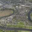
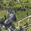
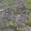
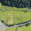
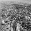
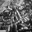
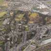
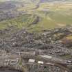
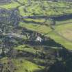
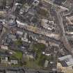
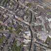
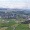
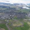
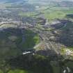
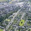
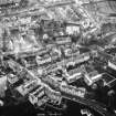
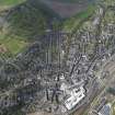
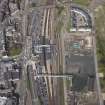
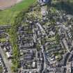
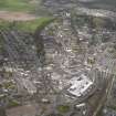
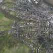
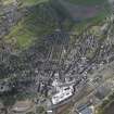
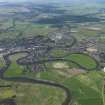
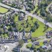
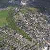
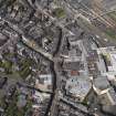
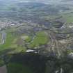
Stirling was one of the principal burghs of medieval Scotland, and the core of the burgh survives as one of the county's best remaining examples of a medieval street plan. In addition, it contains a major collection of 16th and 17th century buildings that reflect its importance as a royal centre in the late medieval period.

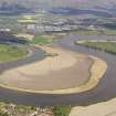
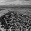
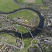
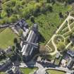
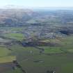
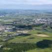
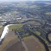
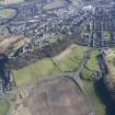
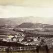
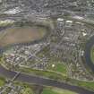
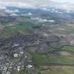
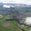
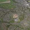
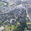
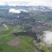
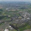
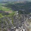
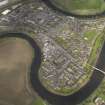
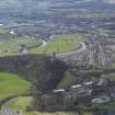
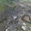
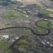
Like its rival Edinburgh, Stirling is dominated by a royal castle (no. 36), and the town developed on a restricted site along the crest of a glacially sculpted ridge in the lee of the castle. The town occupies a nodal position at the highest tidal reach of the Forth (like Perth on the Tay) which also coincides with the lowest bridging point of the river (for a description of the medieval bridge, see no. 16), making it the furthest navigable port for sea-going craft. The significance of sea-borne transport and trade should not be overlooked in the medieval period, and Stirling's position can be contrasted with that of the late medieval royal centre at Linlithgow, West Lothian, where it was necessary to protect its port, Blackness, with a castle (no. 30). Thus Stirling stood at the junction of major land and sea routes, but the success of the burgh also depended on the presence of the royal castle. The town flourished as the royal court continued to be held there, and it enjoyed a golden age from the 15th to the 17th centuries, but with the union of the crowns Stirling's importance waned. When prosperity picked up again in the 19th century, the focus of settlement shifted away from the Castle Rock to lower ground and in doing"so saved the medieval core from major redevelopment.

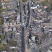
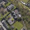
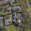
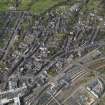
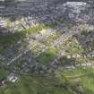
The Castle Rock has probably been occupied continuously since prehistoric times, but no trace of pre-Norman civil settlement has been found and the only evidence for use during the early historic period comes from documentary references. Stirling was one of the earliest towns to achieve burgh status, and it was probably granted this privilege by David I during the first half of the 13th century. The main axis of the medieval town lay along the crest of the ridge (the modem Castle Wynd, St John Street, Spittal Street, Baker Street, King Street) with the Church of the Holy Rude (no. 10) standing on high ground above the principal street (Broad Street). Although the street pattern was probably established during the High Middle Ages, no buildings of this period survive, and excavation in other Scottish medieval burghs has suggested that most buildings would have been of timber. Stone replaced timber as the main building material during the 16th and 17th centuries, and it is to this period that most of the important buildings in the medieval town belong. A particular feature of Stirling are the town houses of the 16th and 17th centuries, ranging from those of courtiers (Argyll Lodging no. 11 and Mar's Work no. 12) to lesser houses belonging to town burgesses (Norrie's House, Broad Street, no. 14, and Cowane's House in St Mary's Wynd). The most important buildings and monuments in the town are described in detail below.

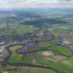
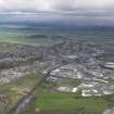
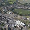
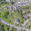
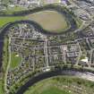
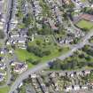
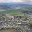
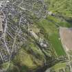
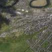
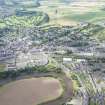
In the 18th and 19th centuries development took place on the lower ground away from the historic core of the burgh. As the town expanded, it incorporated outlying villages including St Ninians with its fine church steeple built in 1734. The Victorian town centre has been much altered, but there are attractive late 19th century residential areas still surviving on the west side of the town.

Information from ‘Exploring Scotland’s Heritage: The Clyde Estuary and Central Region’, (1985).

References

MyCanmore Image Contributions


Contribute an Image

MyCanmore Text Contributions