|
Photographs and Off-line Digital Images |
DP 121943 |
Buildings at Risk Register |
Garrion Tower Front elevation |
28/2/2008 |
Item Level |
|
 |
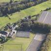
On-line Digital Images |
DP 144547 |
RCAHMS Aerial Photography Digital |
Oblique aerial view of Garrion Tower, taken from the E. |
16/10/2012 |
Item Level |
|
 |
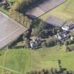
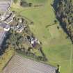
On-line Digital Images |
DP 144548 |
RCAHMS Aerial Photography Digital |
Oblique aerial view of Garrion Tower, taken from the NE. |
16/10/2012 |
Item Level |
|
 |
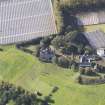
On-line Digital Images |
DP 144550 |
RCAHMS Aerial Photography Digital |
Oblique aerial view of Garrion Tower, taken from the W. |
16/10/2012 |
Item Level |
|
 |
On-line Digital Images |
DP 144551 |
RCAHMS Aerial Photography Digital |
Oblique aerial view of Garrion Tower, taken from the SW. |
16/10/2012 |
Item Level |
|
 |
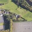
On-line Digital Images |
DP 144552 |
RCAHMS Aerial Photography Digital |
Oblique aerial view of Garrion Tower, taken from the SSW. |
16/10/2012 |
Item Level |
|
 |
On-line Digital Images |
SC 2430119 |
Records of the Ordnance Survey, Southampton, Hampshire, England |
Garrion Tower, NS75SE 14, Ordnance Survey index card, Recto |
c. 1958 |
Item Level |
|
 |
On-line Digital Images |
SC 2430120 |
Records of the Ordnance Survey, Southampton, Hampshire, England |
Garrion Tower, NS75SE 14, Ordnance Survey index card, page number 1, Recto |
c. 1958 |
Item Level |
|
|
All Other |
551 166/1/1 |
Records of the Ordnance Survey, Southampton, Hampshire, England |
Archaeological site card index ('495' cards) |
1947 |
Sub-Group Level |
|


