
Pricing Change
New pricing for orders of material from this site will come into place shortly. Charges for supply of digital images, digitisation on demand, prints and licensing will be altered.
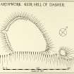
Keir Hill Of Dasher


Earthwork (Prehistoric) - (Medieval)(Possible)
Site Name Keir Hill Of Dasher
Classification Earthwork (Prehistoric) - (Medieval)(Possible)
Canmore ID 45348
Site Number NS69NE 3
NGR NS 65344 95112
Datum OSGB36 - NGR
Permalink http://canmore.org.uk/site/45348


- Council Stirling
- Parish Kippen
- Former Region Central
- Former District Stirling
- Former County Stirlingshire
NS69NE 3 6534 9511
(NS 6534 9511) Keir Hill of Dasher (NAT)
OS 6" map (1958)
Earthwork, Keir Hill of Dasher: This earthwork stands on a rocky promontory on the left bank of the Cuthbertston Burn at a height of 110 ft OD. It measures internally 135ft from ENE to WSW by 100ft transversely, is defined partly by a stony bank measuring up to 33ft in thickness and 4ft in height, and partly by the crest of the steep rocky bank of the burn. At the E apex and bank is accompanied by an external ditch which cuts off the tip of the promontory; the height from the bottom of the ditch to the crest of the bank is 14ft 6in, while that to the outer lip is 2ft 6in. A gap in the W side of the earthwork, 5ft in width, presumably represents the original entrance. The interior has been under cultivation and is featureless.
The date and purpose of the work are unknown, but it is reported in the Ordnance Survey Name Book that "on this hill it is supposed that the old church stood, which was dedicated to St Mauvais, who is the tutelary Saint of this Parish, and the hill is frequently called the Kirk Hill on this account; but there are no records of this being the case, it is merely traditional".
An alternative possibility is that it was a motte.
RCAHMS 1963
As described.
Revised at 1/2500.
Visited by OS (RD) 24 September 1968
Field Visit (August 1978)
Keir Hill of Dasher NS 653 951 NS69NE 3
This earthwork encloses an area measuring 40m from ENE to WSW by 30m transversely, and consists of a stony bank up to 10m thick and 1.2m high, with an external ditch at the E end.
RCAHMS 1979, visited August 1978
(RCAHMS 1963, p. 418, no. 485)
Archaeological Evaluation (27 May 2022 - 30 May 2022)
NS 65344 95113 In May 2022, a second season of research at Keir Hill of Dasher, Kippen focused on the eastern boundary of
the enclosure, which was found to be 6m wide and 1.8m deep. A single tip line was recovered from its basal fill and radiocarbon dates are proposed. Further trenches explored the field to the E and identified what may be a cobbled holloway.
Archive: NRHE (intended)
Funder: Kippen Heritage and Rampart Scotland
Murray Cook, Michelle MacIver, Jennifer Strachan and Sue MacKay – Stirling Council
(Source: DES Volume 23)

