
Pricing Change
New pricing for orders of material from this site will come into place shortly. Charges for supply of digital images, digitisation on demand, prints and licensing will be altered.
Cawder


Linear Feature(S) (Period Unknown)
Site Name Cawder
Classification Linear Feature(S) (Period Unknown)
Alternative Name(s) Cawder Golf Course
Canmore ID 45243
Site Number NS67SW 12
NGR NS 60872 72190
NGR Description From NS 6090 7233 to NS 6082 7207
Datum OSGB36 - NGR
Permalink http://canmore.org.uk/site/45243


- Council East Dunbartonshire
- Parish Cadder (Strathkelvin-du)
- Former Region Strathclyde
- Former District Strathkelvin
- Former County Lanarkshire
NS67SW 12 6082 7207 to 6090 7233.
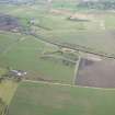
NS 6090 7233 to NS 6082 7207. Cropmarks reveal a ditch running from NNE to SSW across Cawder Golf Course, about 550m SSE of the clubhouse.
There are no traces of any feature to be seen on the ground.
Visited by OS (J L D) 11 February 1954; Visible on CUCAP air
photograph 26Q.
Note (1982)
Cawder Golf Course NS 609 723 to 608 720 NS67SW 12
A ditch revealed by cropmarks running from NNE to SSW across Cawder Golf Course, about 550m SSE of the clubhouse, has been destroyed by gravel quarrying.
RCAHMS 1982

