
Meikle Reive


Cairn (Modern), Fort (Iron Age)
Site Name Meikle Reive
Classification Cairn (Modern), Fort (Iron Age)
Canmore ID 45194
Site Number NS67NW 6
NGR NS 63923 78925
Datum OSGB36 - NGR
Permalink http://canmore.org.uk/site/45194


- Council East Dunbartonshire
- Parish Campsie
- Former Region Strathclyde
- Former District Strathkelvin
- Former County Stirlingshire
NS67NW 6 6392 7893.
(NS 6392 7893) Meikle Reive (NR)
OS 6" map, (1958)
This fort is as described and planned.
Resurveyed at 1:2500.
Visited by OS (J L D) 26 March 1957 and (W D J) 7 May 1966.
Field Visit (26 June 1953)
NS67NW 639 789
Fort, Meikle Reive.
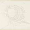
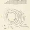
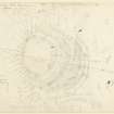
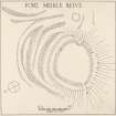
This fort is situated on the S. face of the Campsie Fells, 1100 yds. NE. of Bencloich farmhouse, and at a height of a little over 700 ft. O.D. It occupies a knoll which protrudes from the face of the hillside and may thus be overlooked from the N. The fort is roughly oval on plan (Fig. 17), measuring 145 ft. from E. to W. by 120 ft. transversely within the ruins of a stone wall which are spread to a width of between 15ft. and 20 ft. Excavation (1) has shown that this wall originally measured 12 ft. in thickness. Outside the wall there is a terrace about 14 ft. in width, from the outer margin of which a few earthfast boulders protrude. Immediately to N. and NW. easy access is offered to the fort from the hillside by a broad neck of land, and this is barred by a series of ramparts and ditches which extend in depth for more than 100 ft. The fort has two entrances; the larger one, which was probably the main entrance, lies on the E. and the smaller one on the W. The interior is grass-grown and featureless. About 100 ft. E. of the E. entrance there is a circular depression, 30 ft. in diameter, which is often full of water; it may have been a pond used by the occupants of the fort. A modern cairn stands on the NE.arc of the wall.
As seen on the surface the structure appears to be an Early Iron Age fort of conventional type, and the small finds from the excavation seem to confirm this; they included a number of pieces of hand-made pottery, a stone ball, a sandstone disc, and fragments of a shale armlet and a stone ring. The excavators reported traces of part of what might have been an earlier rampart close to the inner face of the N. arc of the main wall, but as the latter was not sectioned the certain existence and true nature of the supposed earlier remains were not proved; they were thought, however, to consist of post-holes belonging to the inner revetment of a core of earth and brushwood. No positive evidence of a post-Roman occupation was found, although, as only about one fourteenth of the interior of the fort was examined, this negative evidence cannot be regarded as conclusive.
RCAHMS 1963, visited 26 June 1953.
(1) TGAS, new series, xiv (1956), 64 ff.
Excavation (July 1954)
Investigations by the Glasgow Archaeological Society commenced in July and were continued for three weeks in broken weather. The main enclosure about fifty yards in diameter, lies on the flat top of a small hill overlooked by the Campsies immediately to the north. Excavation showed that this enclosure was surrounded by a stone wall 12 feet thick; the revetments were formed of large slabs and blocks, apparently with a filling of smaller stones between, though a section has not been cut. The wall had been sited so that there was a distinct platform between the outer revetment and the steep slope down the hill. Surface indications suggested too entrances, one in the S.E. and one in the west. The latter was found to consist of a passage way extending obliquely down the hill well beyond the wall; the sides were rather badly ruined, but it is clear that the inner end was only 3 feet 2 inches wide. Well worn stone steps formed part of the pavement. Immediately inside the enclosure were the foundations of part of a circular hut in such a position as seriously to impede the entrance way. The slope of the hill to the north of the entrance passage was scarped to form too and possibly three platforms, which converged upon the revetment of the passage.
The approach to the hill from the north formerly consisted of a neck of higher ground which thus formed a weak flank; this had been strengthened by three ramparts and three ditches, crescentic in plan. A section was cut outwards from the wall, across the platform, and as far as the outer side of the middle rampart. The ramparts themselves were smooth banks of earth and stone, but on the summit of the inner one very large boulders were found to be spaced closely along the top as an additional defence. The inner ditch was in the form of a narrow V, 11 feet deep at the section; the inner side was almost vertical and had been strengthened by dry stone walling between large boulders in situ, but this revetment had slumped down into the ditch.
Clear evidence of occupation was everywhere apparent. Carbon, slag and coal appeared frequently and proof was obtained that coal was used as a fuel. Of pottery there was not a trace, and a crude stone lamp and a spindle whorl were the only manufactured objects recorded. Two pieces of stone, probably dressed to a shape, were too much of a puzzle to be anything more than tantalising. So far there is nothing to suggest more than one period of occupation.
Dr H Fairhurst (DES 1954, 16-7)
Excavation (June 1955 - June 1955)
The Glasgow Archaeological Society's excavations on the site of the Meikle Reive, the hill fort on the slope of the Campsies above Lennoxtown, were continued for a period of three weeks during late June and early July, 1955.
The section across the crescent-shaped series of ramparts and ditches along the northern flank of the fort, was; continued from the middle rampart across to the outermost ditch. The outer defences proved less elaborate than those examined last year and incorporated natural hillocks and hollows to an extent not previously suspected. The whole series appears to belong to one period; no occupational material whatever was obtained from the ditches. The rampart forming the main enclosure on the south flank of the fort consists of a mound with a stone kerb instead of the well-built walling exposed on the north side last year.
Much of the season's work was devoted to the interior, partly to investigate further the character of the buildings located previously, and particularly to discover some dateable object. The foundations uncovered were of rather indefinite form; reconstruction was detected, confirming the impression that the Meikle Reive was occupied for a not inconsiderable period. Part of a black shale ‘armlet’, a stone ball, and some fragments of extremely coarse pottery were found, but relies generally were so few - there was a complete absence of quern stones — as to constitute a problem in interpretation, and the dating remains doubtful.
The site is peculiar in some respects, owing to its location on a landslip and seems to be one which, in view of the poverty in dateable material, might be better interpreted when comparative material has become available from less problematical sites. The eastern half of this more or less symmetrical fort has been left completely untouched.
Dr H Fairhurst (DES 1955, 31-2)
Field Visit (February 1982)
Meikle Reive NS 639 789 NS67NW 6
This fort, which occupies a knoll 550m NE of Bencloich Mains, measures about 44m by 36.5m within a wall 3.6m in thickness; there are entrances on the E and W respectively, and additional defence is provided on the N and NE by a complex series of ramparts and ditches.
RCAHMS 1982, visited February 1982
(Fairhurst 1956; DES, 1960, 38; RCAHMS 1963, pp. 78-9, No. 78)
Note (11 August 2014 - 16 November 2016)
This fort occupies a hillock that projects from the escarpment forming the southern face of the Campsie Fells. Oval on plan, it measures 44m from E to W by 36m transversely (0.13ha) within a wall reduced to a mound of rubble between 4.5m and 6m thick and up to 1.5m high; occasional outer facing-stones are visible, and excavations in 1954-5 showed that it is 3.6m thick (Fairhurst 1956). Additional protection on the NNE, where the position of the fort offers no topographical advantage, has been provided by a complex belt of ditches and ramparts some 40m deep, which almost certainly represents several periods of construction. Elsewhere on the N the excavators also reported possible remains of an earlier rampart beneath the inner wall, while the terrace immediately to its front, which can be seen round most of its circuit and is accompanied on the S by a few earthfast boulders, is perhaps further evidence of a demolished circuit and a more complex history of construction. The absence of metallic residues from a piece of vitrified stone found in reuse in the interior suggests that it did not come from an industrial process, thus raising the possibility that an earlier phase of the defences had been destroyed by fire. There are entrances on the ESE and W, both of them approached by short lengths of hollowed trackways. Excavations within the interior revealed the presence of stratified deposits, with two successive levels of cobbling and paving, and, overlying the lower, evidence of the stone footing of at least one round-house (Fairhurst 1956). Finds from the excavations included: pottery; a fragment of iron; a stone ball; a stone disc; fragments of a shale armlet; a stone ring; and several stone lamps.
Information from An Atlas of Hillforts of Great Britain and Ireland – 16 November 2016. Atlas of Hillforts SC1466

