
Maiden Castle


Motte And Bailey (12th Century) - (13th Century)
Site Name Maiden Castle
Classification Motte And Bailey (12th Century) - (13th Century)
Alternative Name(s) Garmore
Canmore ID 45177
Site Number NS67NW 12
NGR NS 6431 7848
Datum OSGB36 - NGR
Permalink http://canmore.org.uk/site/45177


- Council East Dunbartonshire
- Parish Campsie
- Former Region Strathclyde
- Former District Strathkelvin
- Former County Stirlingshire
NS67NW 12 6431 7848
(NS 6431 7848) Maiden Castle (NR)
OS 6" map, 1958.
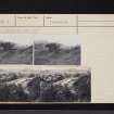
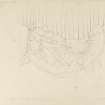
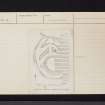
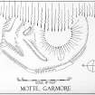
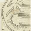
Maiden Castle: This motte and bailey is situated at a height of 500' OD on the S slopes of the Campsie Fells, and on the right bank of a burn which has considerably eroded the remains. In addition, the bailey has been damaged by water from a number of springs on the hillside, by the harnessing of one spring to a piped water supply, and by cultivation. The motte 'A' on plan originally consisted of a circular mound surrounded by a ditch 12' wide, but the burn has removed about a third of both mound and ditch. On the S side the mound rises to a height of 18' above the present bottom of the ditch. The flat top is 57' in diameter, and a drop of 43' from it to the stream-bed. Enough of the bailey survives to suggest that it was originally oval, some 170' by 140'within what is now a grass-covered, stony bank (B), some 12' thick and 2' high. Much of the S and W arcs of this bank remain, but the E part has been washed away by the burn, while the N arc has been mutilated by ploughing.
The space within the bailey N of the motte is occupied by mounds arranged as shown on plan. The inner, a substantial stony bank up to 8' high, starts outside the WNW arc of the motte-ditch, and, after curving for a short distance in conformity with the line of the ditch, runs straight NE for 50'. After a gap 8' wide it continues for 32' SE to come to a broken end on the lip of the gorge of the burn. The outer bank, generally similar in appearance to the inner, follows a similar course. Oval baileys containing curved mounds as well as mottes have been recorded in North Devon and Brecon.
RCAHMS 1963, visited 1953.
Maiden Castle, a motte and bailey, is as described and planned by the RCAHMS.
Surveyed at 1:2500.
Visited by OS (E G C) 31 August 1966.
Field Visit (May 1977)
Maiden Castle, Garmore NS 643 784 NS67NW 12
This motte stands to a height of up to 5.5m within an encircling ditch, and its level summit is 17.5m in diameter; on the E, however, erosion has removed about one-third of both motte and ditch. There are double outer banks on the N and an additional bank flanks the site on the W and S.
RCAHMS 1982, visited May 1977
(RCAHMS 1963, p. 174, No. 183)

