
Pricing Change
New pricing for orders of material from this site will come into place shortly. Charges for supply of digital images, digitisation on demand, prints and licensing will be altered.
Brae Of Achnahaird


Dun (Prehistoric)
Site Name Brae Of Achnahaird
Classification Dun (Prehistoric)
Canmore ID 4489
Site Number NC01SW 3
NGR NC 0170 1380
Datum OSGB36 - NGR
Permalink http://canmore.org.uk/site/4489


- Council Highland
- Parish Lochbroom
- Former Region Highland
- Former District Ross And Cromarty
- Former County Ross And Cromarty
NC01SW 3 0170 1380.
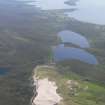
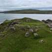
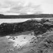
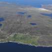
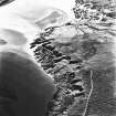
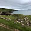
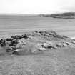
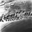
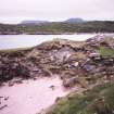
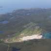
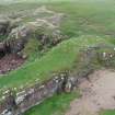
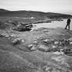
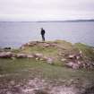
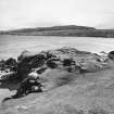
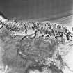
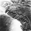
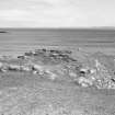
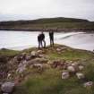
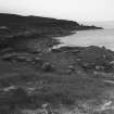
At NC 0170 1380 on a low promontory are the remains of a dun.
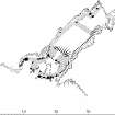
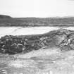
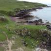
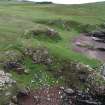
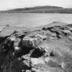
The approach to the promontory has been blocked by a curving wall 2.6m thick. Behind it at a distance of seven metres, a straight wall 3.2m thick crosses the promontory. Together these walls form a forework or blockhouse, roughly D-shaped, which has measured about 5.0m x 5.0m internally. It has until recently been filled with blown sand, but this has been dug away and part of the outer walling mutilated in the process. No entrance is evident. The remainder of the promontory has been enclosed by a drystone wall not more than 1.0m thick built on the edge of a low cliff and now mostly tumbled away on the NE. This has isolated an area behind the forework which now measures 18.0m N-S by 9.0m E-W although rock fall at its N end suggests it may once have been longer.
Surveyed at 1/2500.
Visited by OS (A A) 18 July 1974.
Field Visit (11 August 1994)
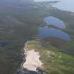
This dun and its outwork occupy a narrow promontory overlooking the S side of Achnahaird Bay. It is roughly rectangular on plan, measuring about 18m from NE to SW by 5.5m transversely within a wall which, where it crosses the neck of the promontory, measures 3m in thickness by 0.9m in height, elsewhere it is of slighter build (1.5m thick) and only survives on the NW, the remainder probably having fallen into the sea. The entrance, which is indicated by a dip in the line of the wall and what may be a door-check on the NW side of the passage, lies in the centre of the cross wall. In the interior the only feature visible is a wall that appears to have been inserted to reduce the size of the space available for occupation. The roughly D-shaped outwork abuts the main cross wall and was probably entered through a passage opposite the main entrance. Within the interior there is a short arc of bank which may have formed part of a later structure, possibly a hut, inserted into the W angle of the outwork. The only other feature is a stretch of walling springing from the W of the outwork which cuts off access from the beach below.
(ACHIL94 470)
Visited by RCAHMS (PJD) 11 August 1994
Measured Survey (22 August 1994)
RCAHMS surveyed the dun at Brae of Achnahaird with alidade and plane-table on 22 August 1995 at a scale of 1:250. The resultant plan was redrawn in ink and published at a scale of 1:500 (RCAHMS 1997c).
Note (9 February 2015 - 31 May 2016)
The remains of a small fortification are situated on a promontory above the rocky foreshore on the W side of the beach in Achnahaird Bay. Its defences comprise two main elements: an outer wall 2.6m in thickness drawn in an arc across the neck of the promontory on the SW; and an inner wall 3m in thickness set square across the promontory some 7m to its rear. The interior of the promontory to the rear of the latter measures about 18m from NE to SW by 5.5m transversely (0.01ha) and was probably enclosed by a slighter wall up to 1.5m in thickness, though this only survives on the NW flank. The remains of the two walls across the neck on the SW were initially interpreted by Alan Ayre of the OS as the remains of D-shaped blockhouse, but later work by RCAHMS regarded the outer as an outwork to a dun; the RCAHMS investigator also suggested that the outwork butted onto the inner wall, though a photograph held by Highland HER showing the junction on the W suggests that it is too ruinous to be certain on this point; likewise the assertion that a dip in the crest of the wall marks the position of a central entrance with a possible door-check on the NW side of the passage.
Information from An Atlas of Hillforts of Great Britain and Ireland – 31 May 2016. Atlas of Hillforts SC2802

