
Nether Wellwood


Mine (Post Medieval)
Site Name Nether Wellwood
Classification Mine (Post Medieval)
Canmore ID 44729
Site Number NS62NE 18
NGR NS 6600 2520
NGR Description Centred NS 6600 2520
Datum OSGB36 - NGR
Permalink http://canmore.org.uk/site/44729


- Council East Ayrshire
- Parish Muirkirk
- Former Region Strathclyde
- Former District Cumnock And Doon Valley
- Former County Ayrshire
Field Visit (February 1991 - November 1991)
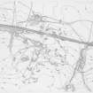
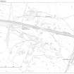
NS62NE 18 6600 2520 (Centred)
NS62NE 18.01 NS 6600 2520 (centred) Mine: Shafts; Horse-engine platforms
NS62NE 18.02 NS 6630 2511 Miner's Cottages
The mining remains at Nether Wellwood belong to the western part of the mineral field which supplied raw materials to the Ironworks at Muirkirk (NS62NE 17). The majority of the mines lie to the S of the dismantled railway (NS62NE 32) and extend W for a distance of 1.4km from the March Burn to the Powharnal Burn. The western half of the area, from the Powharnal Burn to an unnamed burn at Wellwood Siding Cottage, has been largely reclaimed but traces of numerous demolished bings can still be detected. To the E, however, the remains of the mines are much better preserved and were recorded in detail in the course of the survey (NS62NE 18.01). The positions of the mines are marked by bings and in many instances the mouth of the shaft and a machinery stance can still be seen. Other features visible in the vicinity include a number of opencast workings, the footings of a row of miners' cottages (NS62NE 18.02), and several rows of subsidence pits where underground galleries have collapsed. A network of successive transport systems tie together the various features and provide the key to understanding the chronology of the industrial activity.
Visited by RCAHMS (ARW, SPH), February-November 1991.
NMRS MS 731/6.

