
Kames, Muirkirk


Mine (Post Medieval), Tar Works (18th Century)
Site Name Kames, Muirkirk
Classification Mine (Post Medieval), Tar Works (18th Century)
Alternative Name(s) Garpel Water
Canmore ID 44727
Site Number NS62NE 16
NGR NS 6930 2555
NGR Description Centred NS 6930 2555
Datum OSGB36 - NGR
Permalink http://canmore.org.uk/site/44727


- Council East Ayrshire
- Parish Muirkirk
- Former Region Strathclyde
- Former District Cumnock And Doon Valley
- Former County Ayrshire
NS62NE 16.00 centred 6930 2555
NS62NE 16.01 NS 6945 2574 Tarworks
NS62NE 16.02 NS 6930 2555 (centred) Mine: shafts; Horse-engine Platforms
NS62NE 16.03 NS 6926 2582 Miner's Cottages
NS62NE 16.04 NS 6944 2573 Macadam's Cairn
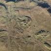
Lord Dundonald established the British Tar Company in 1786 and built tar kilns at Muirkirk which were bought in 1790 by J L McAdam, the celebrated road builder. The surviving stones from the kilns were, in 1931, made into a cairn of rememberance, surrounded by the grass-covered foundations of 34 tar kilns and a number of collapsed bell-pits.
J Butt 1967
Field Visit (February 1991 - November 1991)
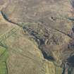
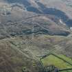
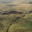
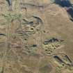
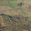
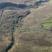
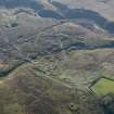
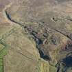
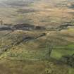
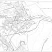
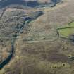
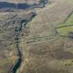
The establishment of a Tarworks to the S of Kames provided the catalyst for the industrial development of Muirkirk (NS62NE 16.01). The foundations of the kilns, still-house and workers' cottages (NS62NE 16.02) can still be seen, and the mining remains which lie immediately to the W of the Tarworks are almost certainly the earliest in the district. Here, the intensity of the mineral extraction is indicated by the closely-spaced shafts with their attendant spoil dumps and horse-engine platforms (NS62NE 16.03). Other features include a series of opencast workings along the E side of the Garpel Water, several large quarries, the largest lying to the S, and the network of tramroads and tracks that carried the raw materials. Clearly, drainage was a problem and the Colt Burn was diverted S away from the area of mining. To overcome the threat of flooding in the mines, several levels were driven, and the outflow of one can still be seen in the E side of the gully of the Garpel Water (NS 6908 2550).
Visited by RCAHMS (ARW, SPH) February-November 1991.
NMRS MS 731/6.
Note (September 2017)
‘Nothing can Induce us to go into such a Desart and Inland place as Muirkirk but the Absolute Certainty of having The Coal, Ironstone and Limestone, very cheap.’
This quotation expresses the sentiments of the Glasgow entrepreneurs who were attracted to Muirkirk by the abundance and accessibility of the area’s mineral resources at the end of the 18th century. Over 200 years later I was confronted with a very similar emotional response, arriving in this remote moorland parish in 1991 as part of the RCAHMS field team. On this occasion however, our remit was to undertake an archaeological survey of the industrial landscape these entrepreneurs had exploited and then abandoned. In all, we mapped 9 square kilometres in detail at a working scale of 1:2500, for the first time allowing the full extent and complexity of this important industrial landscape to be understood. This remains the largest detailed landscape survey RCAHMS has ever undertaken.
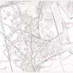
The establishment of the Tar Works was central to the development of the mineral field and this was the first area we surveyed on the ground. While now reduced to rubble footings, the bank of 34 tar kilns can still be seen, surviving as a string of shallow circular bowl-shaped depressions, together with the foundations of the still house and workers’ cottages. These buildings are recorded and annotated on a series of four estate plans held in the National Records of Scotland and dating from 1796 to 1802. The plans also reveal the extent of the initial operations and detail the position and depth of the early coal mines, indicating the limits of the coal seams and the location of some of the levels that were driven to drain and ventilate the mines.
From Tar Works to tarmacadam
From the outset, Lord Dundonald and his brother were assisted by John Loudon MacAdam who at first acted as their agent in Ayr, but by 1789 MacAdam had taken over the position of manager and by 1790 he had acquired the lease. This venture almost brought financial ruin to MacAdam and by the end of 1798 he had left Muirkirk and was later to find fame as a road engineer. His son William remained in charge until 1809 when, despite attempts to offer the site for sale, the Tar Works was abandoned.
MacAdam is best known for the process ‘macadamisation’ and was a great pioneer of road building at a time when modern industrial society was beginning to take shape. He is also renowned for introducing modern methods of professional road management into turnpike roads. He died in Moffat in 1836 after what his son James described as a ‘useful and honourable life’. To commemorate MacAdam’s achievements, a cairn was erected in 1931 on the ruins of the still house opposite the tar works. The stones forming the cairn are said to have come from the tar kilns themselves.
Today, few people driving through Muirkirk will cast an eye south across the River Ayr and perhaps fewer still will recognise the area’s rich industrial past. But far from being a landscape of neglect, of abandoned mines, quarries and spoil dumps, the story told by this landscape is one that celebrates the remarkable achievements of the miners, quarriers and entrepreneurs at the forefront of the Industrial Revolution. As I came to appreciate during the course of our survey many moons ago, this is a landscape worthy of recording and one I would certainly be sad to lose.
Further Reading:
Butt, J 1967 The industrial archaeology of Scotland, The industrial archaeology of the British Isles series, 147-8, 228, Newton Abbot
Findlay, T 1986 Muirkirk - A miscellany, 73-95
Hume and Butt, J R and J 1966 Muirkirk 1786-1802: the creation of a Scottish industrial community', Scot Hist Rev, vol. 45, 1966, 160-183
Reader, W J 1980 Macadam: the McAdam family and the turnpike roads 1798-1861, 27-8, London
Angela R Gannon, Archaeological Field Investigator

