
March Burn


Building(S) (Post Medieval), Enclosure (Post Medieval)
Site Name March Burn
Classification Building(S) (Post Medieval), Enclosure (Post Medieval)
Alternative Name(s) Auchinleck
Canmore ID 44725
Site Number NS62NE 14
NGR NS 6636 2535
Datum OSGB36 - NGR
Permalink http://canmore.org.uk/site/44725


- Council East Ayrshire
- Parish Muirkirk
- Former Region Strathclyde
- Former District Cumnock And Doon Valley
- Former County Ayrshire
Field Visit (7 September 1978)
NS62NE 14 6636 2535.
Sub-rectangular enclosure measuring 27.5m E-W by 17.5m N-S, formed by an earth and stone bank 1.0m high and 3.0m broad. Probably recent.
Visited by OS 7 September 1978.
Field Visit (18 March 1992)
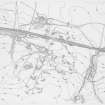
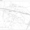
This sub-rectangular enclosure, which is situated immediately S of the dismantled railway line to the W of the March Burn, measures 20.5 from ENE to WSW by 14.5m within a bank spread up to 3.4m in thickness by 0.8m in height, within which there are traces of a possible building. There are the remains of what may be three long, narrow, round-ended buildings disposed on both sides of the dismantled railway at this point. That to the S (NS 6630 2537) is truncated by the railway cutting at its N end and the westerly of the two to the N (NS 6640 2541) is truncated by a tramway at its ENE end: only the easterly of the two to the N is undisturbed, if much reduced. This building (NS 6646 2541), which lies on the lip of some opencast workings on the W bank of the March Burn, splays towards its WSW end and measures 19.5m from NE to SW by between 3.5m and 4.3m transversely within a low bank spread to 1.2m in thickness and 0.2m in height, with a partition 6m from its SW end. Of the other two buildings, that to the N of the railway line is at least 19.3m in length by 2.4m in breadth within banks spread to 2.3m in thickness by 0.5m in height, with a partition immediately ENE of an entrance in the SSE side; that at the S measures at least 16.5m in length by 2.8m within banks spread to 2.1m in thickness by 0.6m in height, which displays an inner face of stone on the E side. A square enclosure lies some 40m S of the building on the S side of the railway line; it measures 7m in breadth within a low turf bank.
Visited by RCAHMS (PJD) 18 March 1992.
Field Visit (1992)
NS 6635 2535 A sub-circular enclosure, measuring approximately 20m E/W by 18m N/S within low banks of maximum height 0.50m and 2.0m wide. The banks, which are grassed over, appear to be of earth/turf and stones. To the immediate E of the enclosure, the ground falls away steeply towards the March Burn; to its N, S and W, the ground is reasonably flat.
Access was at the NE of the enclosure near to which was a low bank that extended some 20m to the N. This arrangement resembles an Iron Age horned entrance system, an interpretation that may be supported by the defensive qualities of the steep river bank. The OS, however, has interpreted the enclosure as being of probable modern age.
Scotia Archaeology Limited 1992
Field Visit (1992)
In addition at NS 6631 2532 is a circular enclosure, 7m to 8m in diameter with low turf walls. Possibly a stell.
J Lewis and D Reed 1992

