
Killearn, Old Parish Church And Graveyard


Burial Ground (Medieval), Church (18th Century)
Site Name Killearn, Old Parish Church And Graveyard
Classification Burial Ground (Medieval), Church (18th Century)
Canmore ID 44593
Site Number NS58NW 7
NGR NS 52290 85869
Datum OSGB36 - NGR
Permalink http://canmore.org.uk/site/44593


- Council Stirling
- Parish Killearn
- Former Region Central
- Former District Stirling
- Former County Stirlingshire
NS58NW 7 52290 85869
See also:
NS58NW 41 Killearn Parish Church
NS58NW 42 Killearn, former Parish Church (Village Hall)
NS58NW 43 Killearn, fomer Free Church (Church Hall)
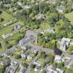
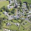
(NS 5229 8587) The old parish church of Killearn, now roofless, stands in a large graveyard. It is dated 1734, and as no work of an earlier period can be seen in the fabric it was presumably built then as a completely new structure, but an older church must have preceded it as many of the tombstones are of the 17th century, and at least 3 slabs were noted, now without inscription, which taper markedly from head to foot, suggesting a medieval date.
The church measures 69'4" by 29'6" over 2'6" thick walls. Traces of foundations below the turf show that an aisle, 12'6" wide, once projected 16' from the centre of the N side.
A new church was built (see NS58NW 41) in 1826 (NSA 1845) though the Ordnance Survey Name Book (ONB, 1861) gives this date as 1836, adding that the old church was unroofed at that time. The shell of the structure was reorganised as family burial grounds in the 19th century.
RCAHMS 1963, visited 1952; New Statistical Account (NSA) 1845; Name Book 1861.
There is no sign of an earlier church and no certain medieval grave slabs.
Visited by OS (B S) 4 December 1973.
EXTERNAL REFERENCE:
Scottish Record Office:
GD/220/6/56
Building of a new church. Payment of £2.6.6/1/2 as the Duke of Montrose's proportion of the cost. Factor's Account Book, 1826
Field Visit (August 1978)
Killearn, Old Parish Church and Burial-ground NS 522 858 NS58NW 7
There was a church at Killearn by the middle of the 13th century. The present church was built in the early 18th century, but 17th-century and possibly earlier gravestones in the graveyard suggest that this is probably the site of the medieval church.
RCAHMS 1979, visited August 1978
(OPS 1851-5, i, 40-1; RCAHMS 1963, pp. 164-5, no. 161)
Photographic Record (31 May 2021)
The stone-built, former parish church is now a consolidated roofless ruin. The southern elevation features both scrolled and mask keystones along with a 1734 date stone. A ball finial survives to the northern elevation. Scrolled skewputs remain but are eroded. Several grave markers have been removed into the interior of the building.
Exterior photographs as a general record upgrade were completed alongside the photographic recording of the adjacent Killearn Hotel. The site investigator’s photographs have been used on this occasion.
Visited by HES Survey and Recording (IF) 31 May 2021.
1) Gifford, J & Walker FA, 2002, The Buildings of Scotland Stirling and Central Scotland. Yale University Press p. 549.

