
Following the launch of trove.scot in February 2025 we are now planning the retiral of some of our webservices. Canmore will be switched off on 24th June 2025. Information about the closure can be found on the HES website: Retiral of HES web services | Historic Environment Scotland
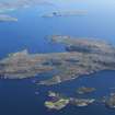
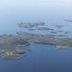
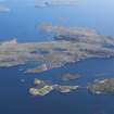
Tanera More, Fishing Station


Fishing Station (18th Century), Pier (18th Century)
Site Name Tanera More, Fishing Station
Classification Fishing Station (18th Century), Pier (18th Century)
Canmore ID 4444
Site Number NB90NE 3
NGR NB 98990 07370
NGR Description Centred NB 98990 07370
Datum OSGB36 - NGR
Permalink http://canmore.org.uk/site/4444


- Council Highland
- Parish Lochbroom
- Former Region Highland
- Former District Ross And Cromarty
- Former County Ross And Cromarty
NB90NE 3 Centred on NB 98990 07370
Standing Building Recording (12 December 2017 - 8 May 2018)
NB 98988 07364 A programme of building survey was undertaken of the ruined herring station. The work consisted of the recording of elevations and plans for the herring station complex and ancillary structures. The structure was in use as a curing facility between the late 18th and early 19th century, thereafter subject to piecemeal re-use, prior to progressive episodes of abandonment into the mid-20th century.
A drawn, written and photographic record was produced for the building complex and its immediate surrounds, including a graveyard to the NW. The metric survey was facilitated by laser scanning and photogrammetric recording.
Information from T. Skinner, K. Macfadyen and C. Dagg – Addyman Archaeology.
(Source: DES Volume 19)
OASIS ID: addymana1-30861

