
Craigmaddie Castle


Tower House (Medieval)
Site Name Craigmaddie Castle
Classification Tower House (Medieval)
Alternative Name(s) Craigmaddie House, Fort And Castle
Canmore ID 44422
Site Number NS57NE 24
NGR NS 57507 76578
Datum OSGB36 - NGR
Permalink http://canmore.org.uk/site/44422


- Council East Dunbartonshire
- Parish Baldernock (Strathkelvin)
- Former Region Strathclyde
- Former District Strathkelvin
- Former County Stirlingshire
NS57NE 24 57507 76578
(NS 5751 7658) Castle (NR) (Remains of)
OS 6" map, (1958)
For surrounding fort (and possible predecessor), see NS57NE 27.
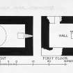
The remains of Craigmaddie Castle comprise a simple tower of 16th century character, reduced to a single storey, standing in a ruinous fort (NS57NE 37).
The oblong tower measures 28ft 2ins by 24ft 6ins over walls some 5ft in thickness. The masonry is rubble. Each floor contains a single chamber. The intact basement is barrel-vaulted, and has a window-silt in each gable.
Debris and vegetation obscure the actual floor, to the level of which parts of the walling are demolished; the NW gable, however, still stands in a solid block, not pierced by any openings, to a height of about 10ft above the floor. The SW end of the SE gable hangs precariously a little higher.
Plainly the tower has been so sited as to take full advantage of the older defensive earthworks within which it stands, and presumably these earlier defences were to some extent restored when the castle was built. It has been said (OSA 1795) that this castle was the stronghold of the Galbraiths of 'Bathernock', ie. Baldernock, who received grants of land from the Earl of Lennox in the 13th century, but the tower of which the ruins now survive belongs to a much later period. It is more likely to have been the home of the Hamiltons, who had acquired the lands by the early 15th century, but had evidently removed to Bardowie Castle by 1556.
Statistical Account (OSA) 1795; RCAHMS 1963, visited 1953.
Craigmaddie Castle is as described and planned by the RCAHMS.
Revised at 1:2500.
Visited by OS (R D) 6 May 1966
Field Visit (June 1977)
Craigmaddie NS 575 765 NS57NE 24
This ruinous tower is situated within the remains of the fort NS57NE 27. Oblong on plan, it stands to first-floor height and is probably of 16th-century date.
RCAHMS 1982, visited June 1977
(RCAHMS 1963, pp. 248-9, No. 206; Talbot 1974, 50, 56)

