
Nethercraig


Farmstead (Period Unassigned)
Site Name Nethercraig
Classification Farmstead (Period Unassigned)
Canmore ID 43913
Site Number NS55SE 12
NGR NS 596 509
Datum OSGB36 - NGR
Permalink http://canmore.org.uk/site/43913


- Council East Renfrewshire
- Parish Eaglesham
- Former Region Strathclyde
- Former District Eastwood
- Former County Renfrewshire
NS55SE 12 596 509.
The remains of Nethercraig Farm (resited late 19th century, to 50m W) are noted for rock-cut foundations and dun-like appearance. (Welsh 1969; Bell 1976). The remains occupy a platform, built up on either side of a ridge, to form an area about 32 by 32m, subrectangular. This is supported by a drystone wall on N and E, and masonry on SW. The main building was originally L-plan, modified as a long-house 30 by 6m. The rock-cut portion is 22m long, on an elevated rock platform; the walls excavated from whinstone, up to 1.5m thick. W of this is a late rectangular building 13.5 by 6m, part masonry, part rock-cut, but here only 70cm thick. A track runs between the buildings, but is post 1864. The Hospitallers' charters are in the Eglinton Munuments, Scottish Record Office.
H W Bell 1976; T C Welsh 1969; 1983.
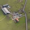
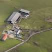
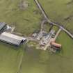
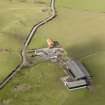
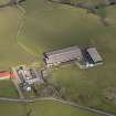
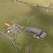
Oblique aerial photographs have recorded the remains of the original Nethercraig farmsteading on a rise immediately SE of the modern (OS 2nd edition, 1897).
The original site of Nethercraig farmstead is depicted on the 1st edition of the OS 25-inch map (Renfrewshire, 1857, sheet 19), which shows four buildings. In addition the map also shows the whinstone quarry immediately to the SE.
The Object Name Book of the Ordnance Survey described the farmsteading as 'A dwelling house and farm yard the property of Mr James Gilmour now occupied by Willm Lindsay' (Name Book 1856)
Information from RCAHMS (DE), April 2008.
This farmstead is situated on a terrace on the NW flank of a craggy ridge some 50m SE of Nethercraigs farmsteading, which succeeded it in the second half of the 19th century. As depicted on the 1st edition of the OS 6-inch map (Renfrewshire 1863, sheet XIX), the earlier farmstead comprised four buildings standing immediately NW of a quarry. Two buildings on the S side of the steading were conjoined to form an L-plan range with its open side facing N, and the other two buildings were situated immediately NNW and NNE respectively. No buildings are depicted here on the 2nd edition of the map (1899, sheet XIX.NE).
Nothing is now visible of the SE wing of the L-plan range, but the SW wing measures at least 14.2m from NW to SE by 5.8m transversely over walls reduced to grass-grown footings. The SW wall has been built along the upper edge of a gully and its outer face is supported on a 1m high drystone revetment that has collapsed at the NW corner. The interior of the building has, in part, been dug out of solid bedrock, and an axial drain, which runs out through the NW end into a possible midden-hollow, indicates that it was probably a byre.
Of the other buildings, both have been reduced to grass-grown footings but only the SW corner the NNE building remains. The NNW building measures 16.5m from NW to SE by 6.6m transversely over all. The interior of this building has also been rock-cut and its opposed entrances indicate that it was probably a barn.
Visited by RCAHMS (PMCK) 18 July 2007.
Field Visit (18 July 2007)
This farmstead is situated on a terrace on the NW flank of a craggy ridge some 50m SE of Nethercraigs farmsteading, which succeeded it in the second half of the 19th century. As depicted on the 1st edition of the OS 6-inch map (Renfrewshire 1863, sheet XIX), the earlier farmstead comprised four buildings standing immediately NW of a quarry. Two buildings on the S side of the steading were conjoined to form an L-plan range with its open side facing N, and the other two buildings were situated immediately NNW and NNE respectively. No buildings are depicted here on the 2nd edition of the map (1899, sheet XIX.NE).
Nothing is now visible of the SE wing of the L-plan range, but SW wing measures at least 14.2m from NW to SE by 5.8m transversely over walls reduced to grass-grown footings. The SW wall has been built along the upper edge of a gully and its outer face is supported on a 1m high drystone revetment that has collapsed at the NW corner. The interior of the building has, in part, been dug out of solid bedrock, and an axial drain, which runs out through the NW end into a possible midden-hollow, indicates that it was probably a byre.
Of the other buildings, both have been reduced to grass-grown footings but only the SW corner the NNE building remains. The NNW building measures 16.5m from NW to SE by 6.6m transversely over all. The interior of this building has also been rock-cut and its opposed entrances indicate that it was probably a barn.
Visited by RCAHMS (PMCK) 18 July 2007.

