 |
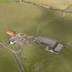
On-line Digital Images |
DP 040146 |
RCAHMS Aerial Photography Digital |
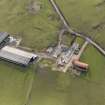
Oblique aerial view centred on the remains of the farmstead/grange with the later farmstead adjacent, taken from the NNW. |
18/3/2008 |
Item Level |
|
 |
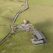
On-line Digital Images |
DP 040147 |
RCAHMS Aerial Photography Digital |
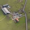
Oblique aerial view centred on the remains of the farmstead/grange with the later farmstead adjacent, taken from the NW. |
18/3/2008 |
Item Level |
|
 |
On-line Digital Images |
DP 040148 |
RCAHMS Aerial Photography Digital |
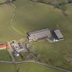
Oblique aerial view centred on the remains of the farmstead/grange with the later farmstead adjacent, taken from the W. |
18/3/2008 |
Item Level |
|
 |
On-line Digital Images |
DP 040149 |
RCAHMS Aerial Photography Digital |
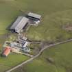
Oblique aerial view centred on the remains of the farmstead/grange with the later farmstead adjacent, taken from the SW. |
18/3/2008 |
Item Level |
|
 |
On-line Digital Images |
DP 040150 |
RCAHMS Aerial Photography Digital |
Oblique aerial view centred on the remains of the farmstead/grange with the later farmstead adjacent, taken from the SE. |
18/3/2008 |
Item Level |
|
 |
On-line Digital Images |
DP 040151 |
RCAHMS Aerial Photography Digital |
Oblique aerial view centred on the remains of the farmstead/grange with the later farmstead adjacent, taken from the SW. |
18/3/2008 |
Item Level |
|
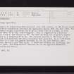 |
On-line Digital Images |
SC 2427087 |
Records of the Ordnance Survey, Southampton, Hampshire, England |
Nethercraig, NS55SE 12, Ordnance Survey index card, Recto |
c. 1958 |
Item Level |
|
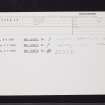 |
On-line Digital Images |
SC 2427088 |
Records of the Ordnance Survey, Southampton, Hampshire, England |
Nethercraig, NS55SE 12, Ordnance Survey index card, Recto |
c. 1958 |
Item Level |
|


