
Lewis, Loch Baravat, Dun Baravat


Broch (Iron Age)(Possible), Galleried Dun (Iron Age)
Site Name Lewis, Loch Baravat, Dun Baravat
Classification Broch (Iron Age)(Possible), Galleried Dun (Iron Age)
Alternative Name(s) North Galson
Canmore ID 4344
Site Number NB45NE 1
NGR NB 46172 59665
Datum OSGB36 - NGR
Permalink http://canmore.org.uk/site/4344


- Council Western Isles
- Parish Barvas
- Former Region Western Isles Islands Area
- Former District Western Isles
- Former County Ross And Cromarty
NB45NE 1 46172 59665.
(NB 462 597) Dun (NR) (Site of)
OS 6"map, Ross-shire, 2nd ed., (1898)
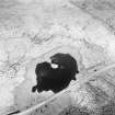
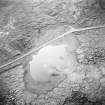
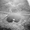
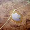
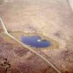
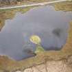
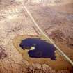
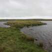
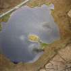
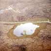
There are the remains of a dun or broch, approached by a causeway, on the larger of the two islands in Loch Bharabhat.
In 1852 no portion of the wall could be traced, but its diameter was estimated at approx. 50ft.
Thomas classifies it as a broch and found "6 or 8ft of it remaining".
By 1914 it had become "a mound of tumbled stones about 70ft in diameter and rising 4ft above the water ... utterly destroyed" and listed as a site.
Name Book 1852; F W L Thomas 1890; RCAHMS 1928.
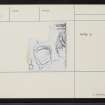
Thomas' plan indicates that this was a galleried dun occupying almost the whole of a small island at NB 4617 5965, but nothing survives except a scatter of stones. The causeway is still visible, but is submerged to a depth of 1ft.
Visited by OS (N K B) 15 June 1969.
Field Visit (14 July 1914)
Dun, Loch Baravat, Galson.
On the west side of the road from Stornoway to Ness, about ½ mile north-east of Galson Lodge, is a small, shallow loch, Loch Baravat. On an islet about 70 feet from the western shore of the loch, with which it is connected by a causeway, is a mound of tumbled stones about 70 feet in diameter and rising 4 feet above the water, the remains of a dun which has been utterly destroyed.
RCAHMS 1928, visited 14 July 1914.
OS map: Lewis ii.
Publication Account (2007)
NB45 2 LOCH BARAVAT
NB/462597
This probable broch in Barvas, Lewis, stands on the larger of two islands in Loch Baravat and is reached by a causeway. In the middle of the 19th century no part of the wall could be seen [1] but a little later Thomas drew a plan of a structure with a galleried wall and reported that there was "6 or 8 ft of it remaining"; he classified the site as a broch [2]. By 1914 the site was completely wrecked [3].
Sources: 1. NMRS site no. NB 45 NE 1: 2. Thomas 1890, 373: 3. RCAHMS 1928, 11, no. 36.
E W MacKie 2007

