
Dumbuie


Dun (Prehistoric)(Possible)
Site Name Dumbuie
Classification Dun (Prehistoric)(Possible)
Alternative Name(s) Dumbowie
Canmore ID 43244
Site Number NS47NW 1
NGR NS 42193 75175
Datum OSGB36 - NGR
Permalink http://canmore.org.uk/site/43244


- Council West Dunbartonshire
- Parish Old Kilpatrick (Dumbarton)
- Former Region Strathclyde
- Former District Dumbarton
- Former County Dunbartonshire
NS47NW 1 4218 7517.
NS47NW 1.01 c.4218 7517 cup and-ring markings (possible)
(NS 4218 7517) Remains of supposed Ancient Watch Tower (NAT)
OS 6" map (1922)
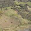
Dunbuie Hill. The remains of this dun were excavated in 1895 by the Helensburgh Natur Antiq Soc when it was found to measure 30ft diameter within a wall 13ft thick a fair amount fo which can still be seen. The entrance in the E is 3ft wide. There were indications of guard chambers on each side of the entrance.
No pot-sherds were found but other finds included bone implements, stone pounders, whetstones and perforated stones and part of two rotary querns - all typically Early Iron Age and probably pre-Roman.
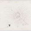
Millar a secretary of the Helensburgh Society also gives accounts and illustrations of several faked weapons of slate which is paralleled by a similar, but larger, assemblage of fantasies from the same Society "found" during their excavation of the Dumbuck Crannog (NS47SW 8). Millar's illustration shows a door check on the northern side of the passage.
R W Feachem 1963; A Millar 1896
As described above. The dun measures 12.6m N-S by 10.0m E-W across.
A terrace about 5.0m wide and 3.5m below the rim fades out on the SE and 3.0m below this terrace another about 6.0m wide and 2.5m high covers the western approaches only. Slight traces of possible ramparts are visible on the edges of both terraces.
Revised at 25" scale.
Visited by OS (WDJ) 30 January 1963
Field Visit (19 May 1955)
This site was included within the RCAHMS Marginal Land Survey (1950-1962), an unpublished rescue project. Site descriptions, organised by county, are available to view online - see the searchable PDF in 'Digital Items'. These vary from short notes, to lengthy and full descriptions. Contemporary plane-table surveys and inked drawings, where available, can be viewed online in most cases - see 'Digital Images'. The original typecripts, notebooks and drawings can also be viewed in the RCAHMS search room.
Information from RCAHMS (GFG) 19 July 2013.
Field Visit (December 1977)
Dumbowie NS 421 751 NS47NW 1
This dun stands at a height of 152 m OD on the summit of a steep-sided knoll looking SW over the River Clyde. It was excavated in the late 19th century when a stone wall 4.1 m thick was found to enclose an area 9.1 m to 9.7 m in diameter. There was an entrance 1 m wide on the E. On the W flank of the knoll, below the dun itself, two terraces 4m broad may suggest additional defences. The finds from the excavation included bone implements, stone pounders, whetstones, perforated stones, parts of two rotary querns as well as a number of stones with cup-and-ring and other markings of doubtful authenticity, and several faked weapons of slate similar to those found at the Dumbuck crannog (NS47SW 8), which was excavated in 1898.
RCAHMS 1978, visited December 1977
(Millar 1896; Feachem 1977, 181)

