
Riccarton


Earthwork (Period Unassigned)
Site Name Riccarton
Classification Earthwork (Period Unassigned)
Alternative Name(s) Trees
Canmore ID 42870
Site Number NS43SW 5
NGR NS 4474 3317
Datum OSGB36 - NGR
Permalink http://canmore.org.uk/site/42870


- Council East Ayrshire
- Parish Riccarton
- Former Region Strathclyde
- Former District Kilmarnock And Loudoun
- Former County Ayrshire
NS43SW 5 4474 3317.
(NS 4474 3317) Earthwork (NR)
OS 6" map (1969)
A ploughed-out earthwork at Trees appears as a crop mark on air photographs.
Information from K A Steer (RCAHMS) letter, 16 April 1954.
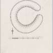
The earthwork is in a once ploughed pasture field on level ground at the foot of a very gentle SE facing slope. It consists of a low circular mound with an external ditch, the overall diameter being 42.0m. There is a causeway over the ditch on E side.
Surveyed at 1:2500.
Visited by OS (EGC) 14 February 1962
This earthwork, situated as described at about 90m OD in an arable field, has been severely reduced by cultivation. The slightly domed interior measures about 25m in overall diameter and 0.4 m high, while the negligible depression of the surrounding ditch, about 0.2m deep, is from about 7.0m wide on the N to about 10.0m wide on the S. The causeway appears to be an original feature, which may suggest that this is a small settlement or homestead.
RAF air photographs show a distinct sub-circular cropmark of the ditch, much narrower (about 1m) than surface remains would indicate.
Revised at 1:2500.
Visited by OS (JRL) 22 June 1982
Field Visit (17 March 1953)
Earthwork, Trees.
In a flat, cultivated field 300 yds south of the farm of Trees there are the faint remains of a circular earthwork consisting of a slightly raised platform bounded by single ditch. The platform measures 70 ft in diameter across the top, while the ditch, which was formerly boggy in wet weather but has recently been filled almost to the present ground level with cinders, has an effective width of 30 ft. The only entrance is situated on the eastern arc and is 13 ft wide. The date and purpose of the work are unknown.
Visited by RCAHMS (KAS) 17 March 1953.
cf. National Survey air photographs 106G/SCOT/UK 87, 4182-3 and 540/827, 3157-8.
Reference (1957)
This site is noted in the ‘List of monuments discovered during the survey of marginal land (1951-5)’ (RCAHMS 1957, xiv-xviii).
Information from RCAHMS (GFG), 24 October 2012.

