|
Photographs and Off-line Digital Images |
A 78948 CN |
Records of the Ordnance Survey, Southampton, Hampshire, England |
View from South-East. |
1982 |
Item Level |
|
|
Photographs and Off-line Digital Images |
B 11562 CN |
Records of the Ordnance Survey, Southampton, Hampshire, England |
View from North-West. |
1982 |
Item Level |
|
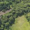 |
On-line Digital Images |
DP 071678 |
RCAHMS Aerial Photography Digital |
Oblique aerial view of Treesbank House dovecot, taken from the N. |
16/6/2009 |
Item Level |
|
|
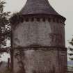
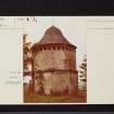
Photographs and Off-line Digital Images |
DP 122679 |
Buildings at Risk Register |
Treesbank House Doocot North elevation. |
22/1/2010 |
Item Level |
|
|
Photographs and Off-line Digital Images |
DP 122680 |
Buildings at Risk Register |
Treesbank House Doocot Approach from east. |
22/1/2010 |
Item Level |
|
|
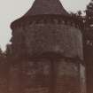
Photographs and Off-line Digital Images |
DP 122681 |
Buildings at Risk Register |
Treesbank House Doocot West elevation. |
22/1/2010 |
Item Level |
|
|
Photographs and Off-line Digital Images |
DP 122682 |
Buildings at Risk Register |
Treesbank Doocot East elevation. |
6/8/2008 |
Item Level |
|
|
Photographs and Off-line Digital Images |
DP 122683 |
Buildings at Risk Register |
Treesbank Doocot |
6/8/2008 |
Item Level |
|
|
Photographs and Off-line Digital Images |
DP 122684 |
Buildings at Risk Register |
Treesbank Doocot Detail of blocked doorway. |
6/8/2008 |
Item Level |
|
|
Photographs and Off-line Digital Images |
DP 205250 |
Buildings at Risk Register |
Front Elevation |
5/11/2014 |
Item Level |
|
|
Photographs and Off-line Digital Images |
DP 205251 |
Buildings at Risk Register |
Rear Elevation |
5/11/2014 |
Item Level |
|
 |
On-line Digital Images |
SC 2613891 |
Records of the Ordnance Survey, Southampton, Hampshire, England |
View from South-East. |
1982 |
Item Level |
|
 |
On-line Digital Images |
SC 2613892 |
Records of the Ordnance Survey, Southampton, Hampshire, England |
View from North-West. |
1982 |
Item Level |
|
 |
On-line Digital Images |
SC 2714158 |
Records of the Ordnance Survey, Southampton, Hampshire, England |
Treesbanks, NS43SW 15, Ordnance Survey index card, page number 1, Recto |
c. 1958 |
Item Level |
|
 |
On-line Digital Images |
SC 2714159 |
Records of the Ordnance Survey, Southampton, Hampshire, England |
Treesbanks, NS43SW 15, Ordnance Survey index card, Recto |
c. 1958 |
Item Level |
|
 |
On-line Digital Images |
SC 2714160 |
Records of the Ordnance Survey, Southampton, Hampshire, England |
Treesbanks, NS43SW 15, Ordnance Survey index card, Recto |
c. 1958 |
Item Level |
|
|
All Other |
551 166/1/1 |
Records of the Ordnance Survey, Southampton, Hampshire, England |
Archaeological site card index ('495' cards) |
1947 |
Sub-Group Level |
|


