Knockmade Hill
Settlement (Period Unassigned)
Site Name Knockmade Hill
Classification Settlement (Period Unassigned)
Canmore ID 42327
Site Number NS36SE 6
NGR NS 3524 6182
Datum OSGB36 - NGR
Permalink http://canmore.org.uk/site/42327
- Council Renfrewshire
- Parish Lochwinnoch
- Former Region Strathclyde
- Former District Renfrew
- Former County Renfrewshire
NS36SE 6 3524 6182
(NS 3524 6182) Homestead (NR)
OS 6" map (1969)
This site, originally published as the supposed site of a fort, was described 1856 as two circles, represented by stones at irregular distances and by slight hollows, set one within the other on the summit of Knockmade Hill (Name Book 1856).
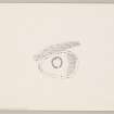
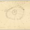
When visited by the OS (JLD) on 4 August 1955, it was noted that: an earth and stone bank 3m to 4m broad and 0.2m high can be traced curving round the S end of the hill, and although not definable on the N, appears to curve to form an enclosure some 40.0m in diameter. Within this area is a smaller circle, 10m in diameter, formed by a circular earth and stone bank 1.2m broad. A plan was made of the site by the RCAHMS, who classify it as a homestead (1957).
This was confirmed by excavations for the Hunterian Museum by R G Livens in 1959-60. Prior to excavating, he notes a group of circular banks within the main enclosures bank, which he showed had been stone-built, about 6ft wide, and overlying a very thin scatter of occupation debris. The principal circular hut was about 40ft in diameter; the extant remains consisted of wall-footings associated with post-holes. The interior was divided into two parts, the one nearer the door being at a slightly lower level and more roughly cobbled; it may have been a byre. The second part was floored with cobbles and gravel and had, in the approximate centre of the hut, an almost circular hearth, surrounded by a stone kerb; past the hearth ran a stone- covered drain. Finds from the site included hammer-stones, and a fragment of a jet or lignite armlet.
R G Livens 1959; R G Livens 1960.
This homestead comprises a 29ft house with E entrance aligned with that of the yard, which is 124ft N-S by 66ft to 82ft. In the S arc of the 8ft wide wall is a 25ft house. The remains occupy a ridge (just over 600ft OD) sheer to the W, steep to the E, but accessible from the N and less readily from the S.
F Newall 1964.
Generally as described above, although the enclosure is a rough oval 40.5m NE - SW by a maximum of 25.0m NW - SE. Its bank is largely traceable only as a scarping of the natural slope, though in places an inner facing scarp, not exceeding 0.2m high, can be discerned, particularly on the north at the highest part of the site. The entrance is in the SE and is 4.0m wide. Opposite the entrance is a hut circle 11.0m diameter formed by a fragmentary turfed-over earth and stone bank, 0.3m high where best preserved. The entrance is in the SE and is 2.5m wide.
The other hut circle, the 25ft house mentioned by Newall, is discernible as a slight depression 8.0m in diameter. The entrance is not apparent.
Surveyed at 1/2500.
Visited by OS (RDL), 14 May 1964.
Scheduled as 'Knockmade Hill, homestead'.
[Further description in text].
Information from Historic Scotland, scheduling document dated 24 February 2011.
Knockmade Hill
Homestead [NAT]
OS (GIS) MasterMap, March 2011.
Field Visit (6 July 1954)
HOMESTEAD,KNOCKMADE HILL.
This structure is situated on a rocky ridge that stands out from the gently-sloping ground on theleft bank of the Kaim Burn, at a distance of a quarter of a mile NNE of Kaim farmhouse. From its NE extremity the ridge rises gradually over a distance of 800 feet to its highest point (623 feet O. D.), beyond which it slopes gently down for a distance of 200 feet and then terminates with a steep, rocky scarp. The homestead is situated on the slope SW of the summit and thus enjoys protection from the NE and exposure to S and SW. It is pear-shaped on plan, measuring 128 feet by 86 feet within the ruins of a stone wall some 8 feet or 9 feet thick. The latter is now represented by several stones of both inner and outer faces which remain in situ and by a scattered rubble core. A mutilated gap in the S arc doubtless represents the entrance.
An almost circular hut is sited at a point 55feet NNW of the entrance to the enclosure. It is represented by a low, grass-grown stony mound spread to a width of 5 feet enclosing an area a little over 30 feet in diameter. It is broken by an entrance gap 6 feet in width at the point nearest to the entrance of the enclosure. Five earthfast boulders forming an arc 12 feet in length lie in the NW quarter of the hut.
While the ground in the W two thirds of the interior of the homestead is reasonably flat, that in the remaining part rises steeply, so that the E arc of the enclosure passes over the summit of the ridge, the point being marked by a modern cairn
NS 352 618
OS map xi SW (Unnoted)
Visited by RCAHMS 6 July 1954
Reference (1957)
This site is noted in the ‘List of monuments discovered during the survey of marginal land (1951-5)’ (RCAHMS 1957, xiv-xviii).
Information from RCAHMS (GFG), 24 October 2012.


