|
Photographs and Off-line Digital Images |
E 59960 CN |
RCAHMS Aerial Photography |
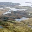
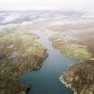
General oblique aerial view looking across Loch Griomsiadair and the townships towards Loch Liurboist, taken from the E. |
29/9/2004 |
Item Level |
|
|
Photographs and Off-line Digital Images |
E 59961 CN |
RCAHMS Aerial Photography |
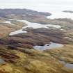
General oblique aerial view looking across Loch Griomsiadair and the townships towards Loch Liurboist, taken from the ENE. |
29/9/2004 |
Item Level |
|
|
Photographs and Off-line Digital Images |
E 59962 CN |
RCAHMS Aerial Photography |
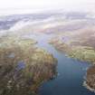
General oblique aerial view looking across Loch Griomsiadair and the townships towards Loch Liurboist, taken from the ENE. |
29/9/2004 |
Item Level |
|
 |
On-line Digital Images |
DP 110487 |
RCAHMS Aerial Photography Digital |
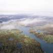
General oblique aerial view of the remains of Dun Loch an Duna, the townships of Grimshader and Ceann Hurnavay, with associated mill and head dyke, Isle of Lewis, taken from the NW. |
14/11/2011 |
Item Level |
|
 |
On-line Digital Images |
DP 110488 |
RCAHMS Aerial Photography Digital |
General oblique aerial view of the remains of Dun Loch an Duna, the townships of Grimshader and Ceann Hurnavay, with associated mill and head dyke, Isle of Lewis, taken from the NW. |
14/11/2011 |
Item Level |
|
 |
On-line Digital Images |
SC 1690869 |
RCAHMS Aerial Photography |
General oblique aerial view looking across Loch Griomsiadair and the townships towards Loch Liurboist, taken from the E. |
29/9/2004 |
Item Level |
|
 |
On-line Digital Images |
SC 1690870 |
RCAHMS Aerial Photography |
General oblique aerial view looking across Loch Griomsiadair and the townships towards Loch Liurboist, taken from the ENE. |
29/9/2004 |
Item Level |
|
 |
On-line Digital Images |
SC 1690871 |
RCAHMS Aerial Photography |
General oblique aerial view looking across Loch Griomsiadair and the townships towards Loch Liurboist, taken from the ENE. |
29/9/2004 |
Item Level |
|
 |
On-line Digital Images |
SC 2345435 |
Records of the Ordnance Survey, Southampton, Hampshire, England |
Lewis, Grimshader, NB32NE 4, Ordnance Survey index card, Recto |
c. 1958 |
Item Level |
|


