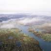
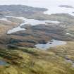
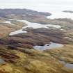
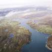
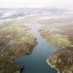
Accessibility

Font Size

100% 150% 200%

Background Colour

Default Contrast
Close Reset

Pricing Change

New pricing for orders of material from this site will come into place shortly. Charges for supply of digital images, digitisation on demand, prints and licensing will be altered. 


Lewis, Grimshader

Township (Period Unassigned)

Site Name Lewis, Grimshader

Classification Township (Period Unassigned)

Canmore ID 4230

Site Number NB32NE 4

NGR NB 3990 2638

NGR Description Centred NB 3990 2638

Datum OSGB36 - NGR

Permalink http://canmore.org.uk/site/4230

Ordnance Survey licence number AC0000807262. All rights reserved.
Canmore Disclaimer. © Bluesky International Limited 2025. Public Sector Viewing Terms

Toggle Aerial | View on large map

Digital Images

Administrative Areas

  • Council Western Isles
  • Parish Lochs
  • Former Region Western Isles Islands Area
  • Former District Western Isles
  • Former County Ross And Cromarty

Archaeology Notes

NB32NE 4.00 centred 3990 2638

NB32NE 4.01 Centred on NB 398 264 Township; Mills

NB32NE 4.02 NB 3971 2625 Horizontal Mill

Information from RCAHMS (SAH) 25 July 1997.

References

MyCanmore Image Contributions


Contribute an Image

MyCanmore Text Contributions