
Loans


Earthwork (Prehistoric)(Possible)
Site Name Loans
Classification Earthwork (Prehistoric)(Possible)
Canmore ID 41989
Site Number NS33SE 9
NGR NS 3522 3230
Datum OSGB36 - NGR
Permalink http://canmore.org.uk/site/41989


- Council South Ayrshire
- Parish Dundonald (Kyle And Carrick)
- Former Region Strathclyde
- Former District Kyle And Carrick
- Former County Ayrshire
NS33SE 9 3522 3230.
NS 352 323. Earthwork, Loans: This feature has been almost entirely ploughed out. Only the ditch defining the NE side, 120ft long, survives, it is some 40ft in width and 3ft to 4ft in depth. In view of the substantial nature of this ditch it seems probable that the earthwork is of Medieval rather tham prehistoric date. If it was rectangular on plan as the existing remains suggest, it may have been a homestead moat.
RCAHMS 1957; MS and plan
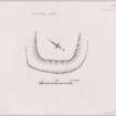
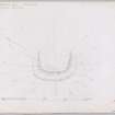
NS 3522 3230. The remains of this earthwork are situated at the SW end of a broad ridge at about 90m OD. Regularly under plough, only the slightly uphill eastern half of the work survives in a coherent form, but ground indications suggest that it was originally sub-rectangular/ oval in shape, measuring internally some 50m NW-SE by 40m transversely with a surrounding ditch up to 12.0m wide and a probable upcast bank. No surface evidence of an inner rampart remains, and a likely entrance in the SW can only be assumed from ground contours. The ditch around the E side is now of a maximum 1.2m in depth, and the outer bank about 0.3m high.
Given the form and location (see also RAF APs F21/58/2712: 0069- 70, flown 1959), there is nothing to suggest it is medieval rather than earlier, and it may well be a prehistoric settlement.
Random surface finds, in plough, within the immediate area of this work include two waste flints, a segment of a circular object in shale (?), and two sherds of green-glazed ware. All were donated to the National Museum of Antiquities of Scotland (NMAS).
Visited by OS (JRL) 30 April 1982
Field Visit (17 March 1953)
NS 352 323. Earthwork, Loans.
This feature has been almost entirely ploughed out. Only the ditch defining the NE side, 120ft long, survives, it is some 40ft in width and 3ft to 4ft in depth. In view of the substantial nature of this ditch it seems probable that the earthwork is of Medieval rather tham prehistoric date. If it was rectangular on plan as the existing remains suggest, it may have been a homestead moat.
Visited by RCAHMS 17 March 1953.
Reference (1957)
This site is noted in the ‘List of monuments discovered during the survey of marginal land (1951-5)’ (RCAHMS 1957, xiv-xviii).
Information from RCAHMS (GFG), 24 October 2012.
Field Visit (April 1985)
Loans NS 3522 3230 NS33SE 9
The remains of an earthwork, severely reduced by cultivation, are situated on the broad crest of a spur 800m NE of the village of Loans. Roughly rectangular on plan, it measures about 44m by 30m within a broad ditch.
RCAHMS 1985, visited (PC) April 1985.
(RCAHMS Survey of Marginal Lands; NMRS, AYD/18/1).

