
Following the launch of trove.scot in February 2025 we are now planning the retiral of some of our webservices. Canmore will be switched off on 24th June 2025. Information about the closure can be found on the HES website: Retiral of HES web services | Historic Environment Scotland
Kemp Law


Dun (Prehistoric)
Site Name Kemp Law
Classification Dun (Prehistoric)
Canmore ID 41981
Site Number NS33SE 3
NGR NS 3558 3364
Datum OSGB36 - NGR
Permalink http://canmore.org.uk/site/41981


- Council South Ayrshire
- Parish Dundonald (Kyle And Carrick)
- Former Region Strathclyde
- Former District Kyle And Carrick
- Former County Ayrshire
NS33SE 3 3558 3364.
(NS 3558 3364) Dun (NR)
OS 6" map (1967)
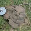
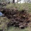
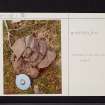
The remains of a dun on Kemp Law are overgrown and much robbed and ruined. The main enclosure is almost circular, measuring about 36ft in diameter within the ruin of a wall 14ft thick. At one point this was found to be vitrified for half its thickness, inwards from the inner face. A second wall can be traced round the dun about 10ft away, but until the site is cleared the details of these are other possible features will remain masked. A shale pin head, 1 1/2ins. in diameter, comparable with one from Traprain Law, was picked up on the surface in 1963, some 10 yds S of the dun.
R W Feachem 1963; D Christison 1893; J L Kay 1963; J Smith 1895
This probable dun has been considerably mutilated and is heavily overgrown. It measures about 20m in diameter over a ruinous wall 1.5m high on the W, and about 0.7m elsewhere. There is a stony mound (possible wall-robbing) near the centre and some of the stones best evidence of vitrification.
Visited by OS (JLD) 29 May 1954
The remains of this overgrown dun, generally as described, are situated in a naturally defensive position at the E end of a narrow spur, at about 90m OD.
The only coherent feature amongst a turf-covered mass of stone debris, some 2.0m high, is a 5m arc of outer facing blocks around the N side. The walling stands up to 1.2m high (about 3 courses) and suggests the original plan was circular and approximately 12m in diameter. A wall thickness cannot be determined, nor can the form and dimensions of the outer wall be assessed.
The quantity of exposed vitrified material is substantial. A rough cutting into the S face of the central mass has exposed a solid band of fused stone beneath an earth capping, and nearby a loose block of vitrified stone measures some 0.5 by 0.4m (cf NS21SE 8).
Revised at 1:2500.
Visited by OS (JRL) 10 May 1982
Field Visit (4 June 1952)
This site was included within the RCAHMS Marginal Land Survey (1950-1962), an unpublished rescue project. Site descriptions, organised by county, are available to view online - see the searchable PDF in 'Digital Items'. These vary from short notes, to lengthy and full descriptions. Contemporary plane-table surveys and inked drawings, where available, can be viewed online in most cases - see 'Digital Images'. The original typecripts, notebooks and drawings can also be viewed in the RCAHMS search room.
Information from RCAHMS (GFG) 19 July 2013.
Field Visit (October 1985)
Kemp Law NS 3558 3364 NS33SE 3
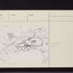
This dun is situated on the steep-sided promontory that forms the ENE end of Kemp Law. It has been reduced to a massive mound of debris which stands within a larger walled enclosure measuring 25m ENE to WSW by 13.5m internally. The mound of debris which measures 17m from ENE to WSW by 10m transversely and stands up to 2.3m in height, contains considerable quantities of vitrifaction. The outer wall has been reduced to a band or rubble around the edges of the promontory, in places mixing up to 0.6m above the level of the interior; on the N the outer face survives to a height of 1.2m in four corners.
RCAHMS 1985, visited (SH) October 1985.
(Smith 1895, 119-20; Christison 1893, 390-1; DES, 1963, 23; Feachem 1977, 179).

