
Following the launch of trove.scot in February 2025 we are now planning the retiral of some of our webservices. Canmore will be switched off on 24th June 2025. Information about the closure can be found on the HES website: Retiral of HES web services | Historic Environment Scotland
Guiltreehill


Earthwork (Prehistoric)
Site Name Guiltreehill
Classification Earthwork (Prehistoric)
Canmore ID 41626
Site Number NS31SE 12
NGR NS 35328 10971
Datum OSGB36 - NGR
Permalink http://canmore.org.uk/site/41626


- Council South Ayrshire
- Parish Kirkmichael (Kyle And Carrick)
- Former Region Strathclyde
- Former District Kyle And Carrick
- Former County Ayrshire
NS31SE 12 NS 35328 10971
(NS 3532 1097) Earthwork (NR)
OS 1:10000 map (1977)
Situated on the W base of Guiltree Hill is the site of an old British camp; it is circular in form and quite level with the general surface. It has not been excavated, but part of an old spear was found in it when it was first ploughed, about fifty years ago.
Name Book 1856; NSA 1845
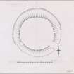
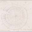
On the rounded summit of a SW spur of Guiltree Hill, about 530ft OD, there is an earthwork, much reduced by cultivation. It is circular on plan and consists of traces of an inner and outer rampart with a medial ditch, now almost completely filled in. The enclosed area measures about 60.0m in diameter; the ditch is some 5.0m wide and 0.5m in depth. The site is known locally as 'Wallace's Ring'.
Visited by OS (JD) 21 November 1955
Generally as described above. It may have been a small settlement, though all traces of internal structures have been obliterated. The name 'Wallace's Ring' could not be confirmed.
Resurveyed at 1:2500.
Visited by OS(WDJ) 11 September 1968
The earthwork is regularly ploughed but its outline is still clearly visible. It is situated on the crest of a flat hilltop with commanding views on all but the NE and E sides. The level interior is higher than the surrounding ground and vestiges of the inner rampart can be identified. The outer rampart is no longer clearly visible and there is no evidence of a causeway across the ditch. It is visible on aerial photographs (RAF/106G/Scot/UK90: 3068-9, flown 1946; CUCAP CHO 50-2, flown 1978); the apparent annexe on the SE side is a fortuitous soil mark.
The origin and purpose of this earthwork are conjectural, but it may be a settlement (cf NS31NE 6 and NS31SW 6).
Visited by OS (MJF) 25 September 1980
Field Visit (28 May 1953)
This site was included within the RCAHMS Marginal Land Survey (1950-1962), an unpublished rescue project. Site descriptions, organised by county, are available to view online - see the searchable PDF in 'Digital Items'. These vary from short notes, to lengthy and full descriptions. Contemporary plane-table surveys and inked drawings, where available, can be viewed online in most cases - see 'Digital Images'. The original typecripts, notebooks and drawings can also be viewed in the RCAHMS search room.
Information from RCAHMS (GFG) 19 July 2013.
Field Visit (August 1982)
Guiltreehill 1 NS 353 109 NS31SE 12
A ploughed-down earthwork, measuring 50m in diameter within a ditch 9m broad, is situated oil the summit of a low hill 580m WNW of Guiltreehill farmhouse. Low swellings in the surface of the field indicate the presence of both an internal and external bank.
RCAHMS 1983, visited August 1982
(Name Book, Ayr, No. 37, p. 43; NSA, v, Ayr, 496; Smith 1895, 183; NM RS, AYD/16/1-2).
Aerial Photographic Transcription (10 June 2011)

