
Pricing Change
New pricing for orders of material from this site will come into place shortly. Charges for supply of digital images, digitisation on demand, prints and licensing will be altered.
Mote Of The Doonans


Dun (Prehistoric)(Possible)
Site Name Mote Of The Doonans
Classification Dun (Prehistoric)(Possible)
Canmore ID 41564
Site Number NS30SE 8
NGR NS 39575 02909
Datum OSGB36 - NGR
Permalink http://canmore.org.uk/site/41564


- Council South Ayrshire
- Parish Straiton (Kyle And Carrick)
- Former Region Strathclyde
- Former District Kyle And Carrick
- Former County Ayrshire
NS30SE 8 3958 0291.
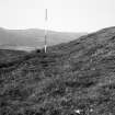
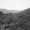
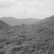
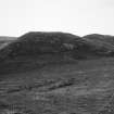
NS 3959 0289. Mote of the Doonans is a natural steep-sided hill 15.2m high which bears traces of possible fortification.
Information from K A Steer, RCAHMS, letter 16 April 1954.
The roughly oval, heather-clad summit measures 19.8m E-W by 7.6m and bears at the W end a fragment, 0.2m high, of an earth-and-stone rampart. Running horizontally along the S face of the hill 1m below the crest there is an artificial terrace 1.8m to 2.1m wide. Some slight indications of the same terrace can be seen on the N and E sides, but there is no trace on the W.
The terrace is clearly not agricultural in origin and the most likely explanation is that it represents the quarried bed for the rampart of a small earthwork in which case an interruption visible in the centre of the terrace on the E may mark the position of an entrance. Whether the work was left unfinished or has been largely destroyed by erosion is uncertain (RCAHMS TS, 6 September 1955).
Visited by OS (JD) 17 November 1955
NS 3958 0291. The possible remains of a fort.
Surveyed at 1:10,000.
Visited by OS (BS) 10 February 1976
This flat-topped conical hill at about 280m OD has no positive indications of artificial work. The alleged rampart at the W end of the summit is a natural rock outcrop. The scarp, up to 1.3m high, and terrace around the summit are striking features, but as defence work they make little sense. If artificial, they reduced an already limited occupiable area by up to a third - to some 160 sq metres, an area too small to be classified as a fort, and too untypically found to be judged a dun.
Visited by OS (JRL) 29 October 1980
Field Visit (6 September 1955)
This site was included within the RCAHMS Marginal Land Survey (1950-1962), an unpublished rescue project. Site descriptions, organised by county, are available to view online - see the searchable PDF in 'Digital Items'. These vary from short notes, to lengthy and full descriptions. Contemporary plane-table surveys and inked drawings, where available, can be viewed online in most cases - see 'Digital Images'. The original typecripts, notebooks and drawings can also be viewed in the RCAHMS search room.
Information from RCAHMS (GFG) 19 July 2013.
Reference (1957)
This site is noted in the ‘List of monuments discovered during the survey of marginal land (1951-5)’ (RCAHMS 1957, xiv-xviii).
Information from RCAHMS (GFG), 24 October 2012.
Field Visit (September 1982)
Mote of the Doonans NS 395 029 NS30SE 8
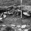
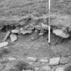
A possible dun is situated on the steep-sided knoll known as the Mote of the Doonans. Around the S arc, about 1.2m below the oval summit (19m by 7.2m), there is a stony scarp 1.8m high, which forms an artificial terrace up to 2. 7m broad on the side of the
knoll; a sheep-rub at the base of the scarp reveals that it is composed of a mass of tumbled masonry from a substantial wall. On the NW there is a terrace, 3.4m broad, cut into the slope at the foot of the knoll.
RCAHMS 1983, visited September 1982
(NM RS, A YD/9/1).

