
Lurg Moor


Fortlet (Roman)
Site Name Lurg Moor
Classification Fortlet (Roman)
Canmore ID 41342
Site Number NS27SE 2
NGR NS 29500 73730
Datum OSGB36 - NGR
Permalink http://canmore.org.uk/site/41342


- Council Inverclyde
- Parish Greenock
- Former Region Strathclyde
- Former District Inverclyde
- Former County Renfrewshire
NS27SE 2 29500 73730
(NS 2950 7373) Roman Fortlet (R)
OS 1:10000 map (1980).
For Roman road extending to S, see NS27SE 49.
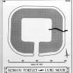
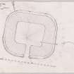
The Roman fortlet on Lurg Moor, which was probably built in the mid-2nd century AD (R W Feachem 1952) was first observed on a National Survey air photograph in 1952. Measuring 160ft by 140ft overall, its E and W sides are well-preserved, the ramparts being 2 1/2ft high and the ditch 3 1/2ft deep. A causeway, about 15ft wide, runs S from the S gate for over 100yds (JRS 1953) (Newall gives the length as 1/4 mile, visible in part as a hollow way).
The area W and S of the fortlet may have been an annexe; S of the fortlet and along the N side of the marsh is a line of heavy stones which may have formed part of a rampart. The remains of an earthen
mound running N-S may mark the W limit of the annexe.
About a dozen fragments of Antonine (A S Robertson 1966) pottery were found by Newall at NS 295 736, immediately SW of the fortlet. This pottery, and a fragment of glass also found by Newall, are in the Hunterian Museum, Glasgow.
F Newall 1955; F Newall 1959.
This Roman fortlet is generally as described by the previous authorities. It measures 52.0m E-W by 44.0, transversely, and has a broad, heather-covered rampart about 10.0m wide. This rampart is beat preserved on the E side where it has an internal height of 0.8m and an external height of 1.6m. Here the rock-cut outer ditch is also well-preserved, the scarp being 0.8m high. The causeway runs due S from the entrance in the S side of the fortlet, and can be easily traced for some 170.m, when it fades out on a rocky knoll above an area of boggy ground. It is about 5.0m in average width, and on places it has a distinct camber about 0.4m hight. It has been built with small stones but here and there use has been made of natural rock outcrops.
There is insufficient evidence on the ground to support Newall's assertion that there was an annexe S and W of the fortlet.
Surveyed at 1:2500.
Visited by OS (WDJ), 4 November 1964.
There is a central gateway on the N side of the fortlet, the causeway from the S passing through the fortlet, and proceeding for some distance down the steep slope to the N.
F Newall 1976.
Visible on Ordnance Survey large scale aerial photograph 88/041/018.
Information from RCAHMS, 24 August 1995.
Roman Fortlet [NAT]
OS (GIS) MasterMap, March 2011.
Scheduled [with length of Roman road NS27SE 49 extending to the S] as 'Lurg Moor, Roman fortlet and Roman road... situated on high ground above the town of Greenock [and] on the northern edge of Lurg Moor.'
Information from Historic Scotland, scheduling document dated 1 March 2011.
Field Visit (17 November 1952)
This site was included within the RCAHMS Marginal Land Survey (1950-1962), an unpublished rescue project. Site descriptions, organised by county, are available to view online - see the searchable PDF in 'Digital Items'. These vary from short notes, to lengthy and full descriptions. Contemporary plane-table surveys and inked drawings, where available, can be viewed online in most cases - see 'Digital Images'. The original typecripts, notebooks and drawings can also be viewed in the RCAHMS search room.
Information from RCAHMS (GFG) 19 July 2013.
Reference (1957)
This site is noted in the ‘List of monuments discovered during the survey of marginal land (1951-5)’ (RCAHMS 1957, xiv-xviii).
Information from RCAHMS (GFG), 24 October 2012.
Publication Account (1985)
Like the west flank of Hadrian's Wall, along the Cumbrian coast, the western flank of the Antonine frontier was protected by a series of stations along the south Clyde coast. The first was a fort at Bishopton, situated on the south bank of the Clyde opposite the end of the Wall at Old Kilpatrick; the second, and best preserved of the series, is this fortlet on Lurg Moor (for the third see Outerwards, no. 77). Rectangular on plan, the fortlet measures 43m by 49m over a turf rampart accompanied by an outer ditch; on the east and west where the defences are particularly well-preserved, the bottom of the ditch is up to 2m below the crest of the rampart. The single entrance lies on the south and, leading out of it for a distance of 100m, there is a causeway 4.5m wide, which probably represents the remains of the road leading towards the next fortlet at Outerwards (no. 77).
Although no excavation has been carried out on this site, several sherds of Antonine pottery have been found immediately outside the fortlet, and there is little doubt that it dates to the Antonine period. The internal arrangements were probably similar to those at Outerwards with a pair of wooden buildings providing accommodation for a small permanent garrison.
Information from ‘Exploring Scotland’s Heritage: The Clyde Estuary and Central Region’, (1985).
Field Visit (November 2012)
As part of a cultural heritage statement CFA Archaeology Ltd undertook field survey to assess the present baseline condition of the known archaeology and heritage features identified through a desk-based assessment as well as to identify any further features of historic environment interest not detected from the deskbased assessment;as well as areas with the potential to contain currently unrecorded buried archaeological remains.
Field survey recorded the fortlet and section of surviving road as described. The road section is most pronounced nearest the fortlet, where a raised linear trackway is visible crossing a natural dip in the local topography.
Information from Helena Gray (CFA Archaeology Ltd) July 2014. OASIS ID: cfaarcha1-263967, no.12
Field Visit (26 February 2015)
This Roman fortlet is located on sloping ground at the edge of a steep bluff overlooking the estuary of the River Clyde about 2.5km to the north. It is rectangular on plan with rounded corners, measuring 55m from WNW to ESE by 48m transversely overall. Described from the outside, the grass-grown earthworks consist of: an irregular counterscarp bank up to 5m thick and 0.25m high on the ESE and SSW, which is overlain by the agger of a road (NS27SE 49) running due S; a stepped, rock-cut ditch up to 6m broad and 0.6m deep interrupted by a causeway on the SSW, and a rampart up to 9m thick and 0.7m high broken by an entrance on the SSW. Deflation of the rampart here has led to an accumulation of soil at the entrance, while run-off from the adjacent peaty moorland has led to waterlogging. This has resulted in the excessive sedimentation of the ditch in that quarter and to the subsidence and deflation of the rampart on the NNE. Internally, the fortlet measures 26m from WNW to ESE by 19m transversely (c.500sqm), but up to a third of this area is occupied by a pronounced natural mound projecting from the SSW, which effectively limits the space for a barrack block to the ESE half. However, at possibly 20m in length, this would be the same size as the two smaller buildings combined that were found facing one another at Outerwards, the neighbouring fortlet situated 10km to the SW (NS26NW 2).
The agger of the approach road to the fortlet, which measures up to 4m broad and 0.3m high, becomes increasingly distinct as it leaves the interior and passes south under the fence and into the heather moorland. It crosses a ribbon of waterlogged ground at the foot of a steep natural scarp, which it climbs until it suddenly stops on a knoll overlooking a large peat-filled basin about 140m south of the fortlet. Traces of the cutting made across the road by Neil Oliver and Anthony Pollard in 1990 are still visible 13m south of the foot of the scarp.
The site appears to have been carefully chosen to maximise the fortlet's outlook over the River Clyde from a timber tower rising above the gateway. This was deliberately situated at the highest point topographically and the view extends from Dumbarton in the east to the mouth of Holy Loch in the west, although it is rapidly foreclosed by rising ground on the south.
Visited by RCAHMS (ATW, GFG, AMcC), 26 February 2015.
Measured Survey (26 February 2015)
RCAHMS surveyed Lurg Moor fortlet with plane-table and self-reducing alidade on 26 February 2015 at a scale of 1:500. Control points and sections were recorded with GNSS. The resultant plan and sections were redrawn in vector graphics software.

