
Brisbane House


Country House (17th Century)
Site Name Brisbane House
Classification Country House (17th Century)
Alternative Name(s) Kelso-land; Kelsoland
Canmore ID 41290
Site Number NS26SW 3
NGR NS 2096 6190
Datum OSGB36 - NGR
Permalink http://canmore.org.uk/site/41290


- Council North Ayrshire
- Parish Largs
- Former Region Strathclyde
- Former District Cunninghame
- Former County Ayrshire
NS26SW 3.01 NS 20834 61623 Meridian Pillars (Observatory)
(NS 2096 6190) Brisbane House (NR) (site of)
OS 6" map (1963)
Brisbane House (NR)
OS 6" map (1909)
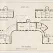
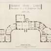
Brisbane House was a mansion in the plain style introduced in the 17th century. It was built in 1636, the date given on one of the skewstones. Two wings were added at a later date.
D MacGibbon and T Ross 1892
The roof was removed from Brisbane House just before 1939, and it was demolished during the last war (P M Robertson, Noddsdale). It is now a pile of rubble. No walls of the 17th century mansion can be seen amid the rubble, but some 19th century parts can be traced.
Visited by OS (JLD) 24 September 1956
Only a part of the 19th century E wing remains. There are no traces of other parts of the building.
Visited by OS Reviser 14 May 1965
Built 1636 and called Kelso-land, changed to Brisbane in 1671.
Demolished between 1920 and 1940.
Information from Demolitions catalogue held in RCAHMS Library.
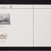
EXTERNAL REFERENCE
BRISBANE HOUSE
SRO/NRA(S)
Scott of Gala
Bundle 723 Engraving N.d.
BRISBANE OBSERVATORY
SRO/NRA(S)
Scott of Gala
Bundle 723 Engraving N.d.

