
Pricing Change
New pricing for orders of material from this site will come into place shortly. Charges for supply of digital images, digitisation on demand, prints and licensing will be altered.
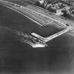
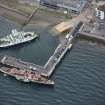
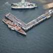
Largs Harbour, Pier


Pier (Period Unassigned)
Site Name Largs Harbour, Pier
Classification Pier (Period Unassigned)
Alternative Name(s) Largs Pier; Largs Harbour, South Pier; Largs Harbour, West Pier
Canmore ID 41181
Site Number NS25NW 35.01
NGR NS 20038 59487
Datum OSGB36 - NGR
Permalink http://canmore.org.uk/site/41181


- Council North Ayrshire
- Parish Largs
- Former Region Strathclyde
- Former District Cunninghame
- Former County Ayrshire
NS25NW 35.01 20038 59487
For associated beacon, see NS25NW 35.02.
The location assigned to this record indicates the midpoint (SW-facing corner) of the structure. The available map evidence indicates that it extends from NS 20049 59535 to NS 20029 59481 to NS c. 20116 59459.
The protected area of the harbour lies to the NE of this pier.
Information from RCAHMS (RJCM), 27 June 2006.

